You are here: Home > Network List > TA - USArray Transportable Network (new EarthScope stations) Stations List
> Station 120A U Bar Ranch, Lordsburg, NM, USA > Earthquake Result Viewer
120A U Bar Ranch, Lordsburg, NM, USA - Earthquake Result Viewer
| Earthquake location: |
Vanuatu Islands |
| Earthquake latitude/longitude: |
-14.8/168.0 |
| Earthquake time(UTC): |
2008/11/07 (312) 07:19:35 GMT |
| Earthquake Depth: |
13 km |
| Earthquake Magnitude: |
6.0 MB, 6.3 MS, 6.4 MW, 6.4 MW |
| Earthquake Catalog/Contributor: |
WHDF/NEIC |
|
| Network: |
TA USArray Transportable Network (new EarthScope stations) |
| Station: |
120A U Bar Ranch, Lordsburg, NM, USA |
| Lat/Lon: |
32.55 N/108.63 W |
| Elevation: |
1528 m |
|
| Distance: |
92.4 deg |
| Az: |
57.098 deg |
| Baz: |
254.03 deg |
| Ray Param: |
0.041467287 |
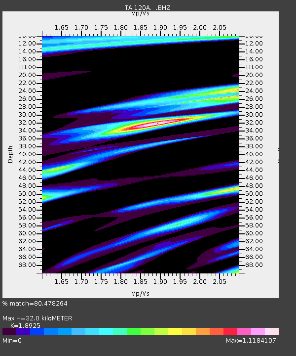
| Estimated Moho Depth: |
32.0 km |
| Estimated Crust Vp/Vs: |
1.89 |
| Assumed Crust Vp: |
6.276 km/s |
| Estimated Crust Vs: |
3.316 km/s |
| Estimated Crust Poisson's Ratio: |
0.31 |
|
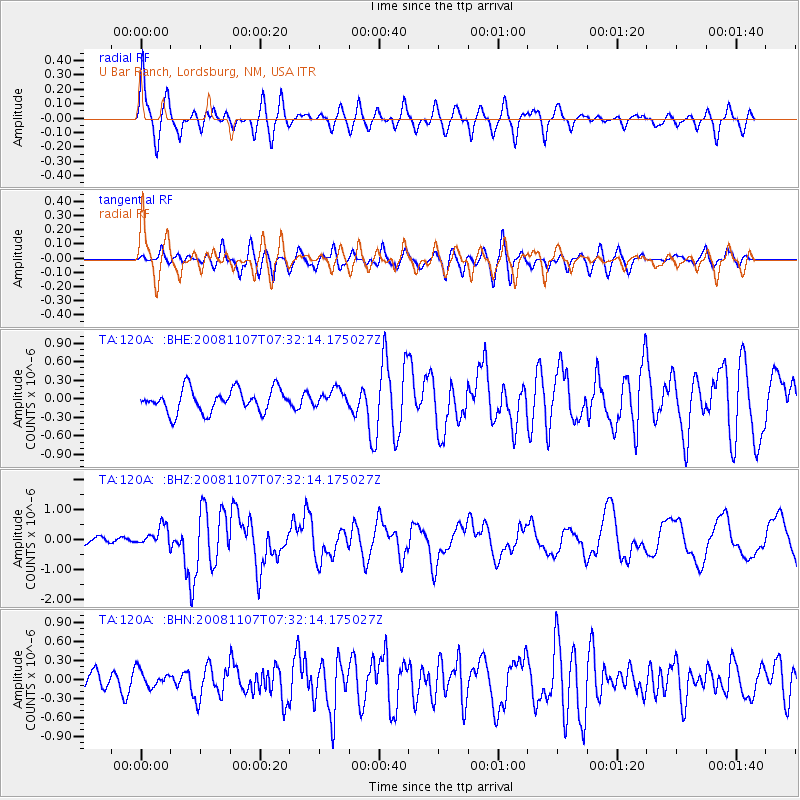
| Radial Match: |
80.478264 % |
| Radial Bump: |
400 |
| Transverse Match: |
67.600006 % |
| Transverse Bump: |
400 |
| SOD ConfigId: |
2658 |
| Insert Time: |
2010-03-06 23:11:43.140 +0000 |
| GWidth: |
2.5 |
| Max Bumps: |
400 |
| Tol: |
0.001 |
|
Signal To Noise
| Channel | StoN | STA | LTA |
| TA:120A: :BHZ:20081107T07:32:14.175027Z | 3.4563448 | 3.2001566E-7 | 9.258789E-8 |
| TA:120A: :BHN:20081107T07:32:14.175027Z | 0.6272686 | 1.3691455E-7 | 2.1827103E-7 |
| TA:120A: :BHE:20081107T07:32:14.175027Z | 0.7387409 | 1.3675869E-7 | 1.8512402E-7 |
| Arrivals |
| Ps | 4.6 SECOND |
| PpPs | 14 SECOND |
| PsPs/PpSs | 19 SECOND |


