You are here: Home > Network List > TA - USArray Transportable Network (new EarthScope stations) Stations List
> Station 120A U Bar Ranch, Lordsburg, NM, USA > Earthquake Result Viewer
120A U Bar Ranch, Lordsburg, NM, USA - Earthquake Result Viewer

| Earthquake location: |
Central Mid-Atlantic Ridge |
| Earthquake latitude/longitude: |
8.1/-38.7 |
| Earthquake time(UTC): |
2008/09/10 (254) 13:08:14 GMT |
| Earthquake Depth: |
10 km |
| Earthquake Magnitude: |
6.3 MB, 6.5 MS, 6.6 MW, 6.6 MW |
| Earthquake Catalog/Contributor: |
WHDF/NEIC |
|
| Network: |
TA USArray Transportable Network (new EarthScope stations) |
| Station: |
120A U Bar Ranch, Lordsburg, NM, USA |
| Lat/Lon: |
32.55 N/108.63 W |
| Elevation: |
1528 m |
|
| Distance: |
68.8 deg |
| Az: |
301.684 deg |
| Baz: |
93.934 deg |
| Ray Param: |
0.05608472 |
| Estimated Moho Depth: |
30.75 km |
| Estimated Crust Vp/Vs: |
1.76 |
| Assumed Crust Vp: |
6.276 km/s |
| Estimated Crust Vs: |
3.556 km/s |
| Estimated Crust Poisson's Ratio: |
0.26 |
|
| Radial Match: |
90.465324 % |
| Radial Bump: |
400 |
| Transverse Match: |
81.19719 % |
| Transverse Bump: |
351 |
| SOD ConfigId: |
2560 |
| Insert Time: |
2010-03-06 23:11:46.940 +0000 |
| GWidth: |
2.5 |
| Max Bumps: |
400 |
| Tol: |
0.001 |
|
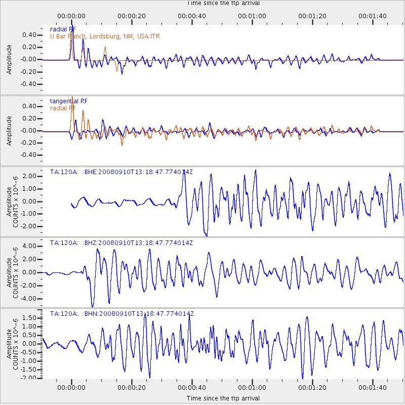
Signal To Noise
| Channel | StoN | STA | LTA |
| TA:120A: :BHZ:20080910T13:18:47.774014Z | 2.1691248 | 3.6486975E-7 | 1.6821059E-7 |
| TA:120A: :BHN:20080910T13:18:47.774014Z | 1.3152472 | 2.4199636E-7 | 1.8399308E-7 |
| TA:120A: :BHE:20080910T13:18:47.774014Z | 0.88111144 | 1.748669E-7 | 1.9846172E-7 |
| Arrivals |
| Ps | 3.9 SECOND |
| PpPs | 13 SECOND |
| PsPs/PpSs | 17 SECOND |


