You are here: Home > Network List > TA - USArray Transportable Network (new EarthScope stations) Stations List
> Station 120A U Bar Ranch, Lordsburg, NM, USA > Earthquake Result Viewer
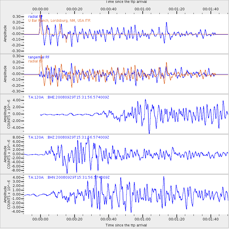
120A U Bar Ranch, Lordsburg, NM, USA - Earthquake Result Viewer
| Earthquake location: |
Kermadec Islands, New Zealand |
| Earthquake latitude/longitude: |
-29.8/-177.7 |
| Earthquake time(UTC): |
2008/09/29 (273) 15:19:31 GMT |
| Earthquake Depth: |
36 km |
| Earthquake Magnitude: |
6.5 MB, 6.7 MS, 7.0 MW, 7.0 MW |
| Earthquake Catalog/Contributor: |
WHDF/NEIC |
|
| Network: |
TA USArray Transportable Network (new EarthScope stations) |
| Station: |
120A U Bar Ranch, Lordsburg, NM, USA |
| Lat/Lon: |
32.55 N/108.63 W |
| Elevation: |
1528 m |
|
| Distance: |
90.1 deg |
| Az: |
52.069 deg |
| Baz: |
234.301 deg |
| Ray Param: |
0.04169273 |
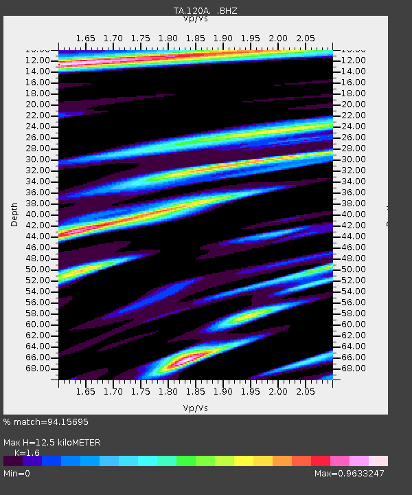
| Estimated Moho Depth: |
12.5 km |
| Estimated Crust Vp/Vs: |
1.60 |
| Assumed Crust Vp: |
6.276 km/s |
| Estimated Crust Vs: |
3.922 km/s |
| Estimated Crust Poisson's Ratio: |
0.18 |
|
| Radial Match: |
94.15695 % |
| Radial Bump: |
400 |
| Transverse Match: |
88.69671 % |
| Transverse Bump: |
400 |
| SOD ConfigId: |
2560 |
| Insert Time: |
2010-03-06 23:11:49.076 +0000 |
| GWidth: |
2.5 |
| Max Bumps: |
400 |
| Tol: |
0.001 |
|
Signal To Noise
| Channel | StoN | STA | LTA |
| TA:120A: :BHZ:20080929T15:31:56.574009Z | 5.067285 | 5.4959764E-7 | 1.0845998E-7 |
| TA:120A: :BHN:20080929T15:31:56.574009Z | 1.1190772 | 1.3376082E-7 | 1.1952778E-7 |
| TA:120A: :BHE:20080929T15:31:56.574009Z | 2.2026231 | 2.8644135E-7 | 1.3004555E-7 |
| Arrivals |
| Ps | 1.2 SECOND |
| PpPs | 5.1 SECOND |
| PsPs/PpSs | 6.3 SECOND |


