You are here: Home > Network List > TS - TERRAscope (Southern California Seismic Network) Stations List
> Station GPO China Lake , California, USA > Earthquake Result Viewer
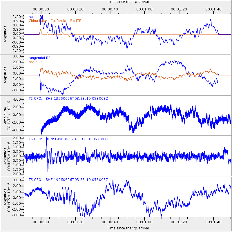
GPO China Lake , California, USA - Earthquake Result Viewer
*The percent match for this event was below the threshold and hence no stack was calculated.
| Earthquake location: |
Bonin Islands, Japan Region |
| Earthquake latitude/longitude: |
27.7/139.7 |
| Earthquake time(UTC): |
1996/06/26 (178) 03:22:03 GMT |
| Earthquake Depth: |
469 km |
| Earthquake Magnitude: |
5.5 MB, 6.3 UNKNOWN, 5.4 MB |
| Earthquake Catalog/Contributor: |
WHDF/NEIC |
|
| Network: |
TS TERRAscope (Southern California Seismic Network) |
| Station: |
GPO China Lake , California, USA |
| Lat/Lon: |
35.65 N/117.66 W |
| Elevation: |
735 m |
|
| Distance: |
83.6 deg |
| Az: |
53.113 deg |
| Baz: |
299.479 deg |
| Ray Param: |
$rayparam |
*The percent match for this event was below the threshold and hence was not used in the summary stack. |
|
| Radial Match: |
41.310997 % |
| Radial Bump: |
400 |
| Transverse Match: |
33.67275 % |
| Transverse Bump: |
400 |
| SOD ConfigId: |
4480 |
| Insert Time: |
2010-02-26 14:14:43.238 +0000 |
| GWidth: |
2.5 |
| Max Bumps: |
400 |
| Tol: |
0.001 |
|
Signal To Noise
| Channel | StoN | STA | LTA |
| TS:GPO: :BHN:19960626T03:33:10.053003Z | 2.6498458 | 6.2029983E-7 | 2.3408903E-7 |
| TS:GPO: :BHE:19960626T03:33:10.053003Z | 0.92314005 | 1.7297444E-6 | 1.8737617E-6 |
| TS:GPO: :BHZ:19960626T03:33:10.053003Z | 1.0290767 | 1.6806323E-6 | 1.6331458E-6 |
| Arrivals |
| Ps | |
| PpPs | |
| PsPs/PpSs | |


