You are here: Home > Network List > TA - USArray Transportable Network (new EarthScope stations) Stations List
> Station 120A U Bar Ranch, Lordsburg, NM, USA > Earthquake Result Viewer
120A U Bar Ranch, Lordsburg, NM, USA - Earthquake Result Viewer
| Earthquake location: |
Samoa Islands Region |
| Earthquake latitude/longitude: |
-15.5/-172.1 |
| Earthquake time(UTC): |
2009/09/29 (272) 17:48:10 GMT |
| Earthquake Depth: |
18 km |
| Earthquake Magnitude: |
7.1 MB, 8.1 MS, 8.1 MW, 8.0 MW |
| Earthquake Catalog/Contributor: |
WHDF/NEIC |
|
| Network: |
TA USArray Transportable Network (new EarthScope stations) |
| Station: |
120A U Bar Ranch, Lordsburg, NM, USA |
| Lat/Lon: |
32.55 N/108.63 W |
| Elevation: |
1528 m |
|
| Distance: |
77.2 deg |
| Az: |
50.795 deg |
| Baz: |
242.199 deg |
| Ray Param: |
0.05047587 |
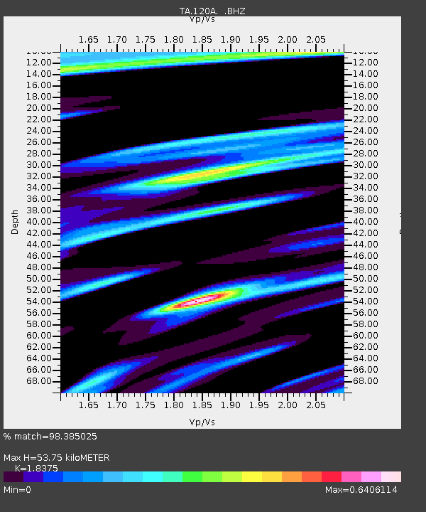
| Estimated Moho Depth: |
53.75 km |
| Estimated Crust Vp/Vs: |
1.84 |
| Assumed Crust Vp: |
6.276 km/s |
| Estimated Crust Vs: |
3.415 km/s |
| Estimated Crust Poisson's Ratio: |
0.29 |
|
| Radial Match: |
98.385025 % |
| Radial Bump: |
400 |
| Transverse Match: |
86.40941 % |
| Transverse Bump: |
400 |
| SOD ConfigId: |
2622 |
| Insert Time: |
2010-03-06 23:12:14.859 +0000 |
| GWidth: |
2.5 |
| Max Bumps: |
400 |
| Tol: |
0.001 |
|

Signal To Noise
| Channel | StoN | STA | LTA |
| TA:120A: :BHZ:20090929T17:59:32.325022Z | 13.844111 | 2.3982375E-6 | 1.732316E-7 |
| TA:120A: :BHN:20090929T17:59:32.325022Z | 2.3677998 | 3.2193356E-7 | 1.3596316E-7 |
| TA:120A: :BHE:20090929T17:59:32.325022Z | 5.0810313 | 6.9241935E-7 | 1.3627536E-7 |
| Arrivals |
| Ps | 7.4 SECOND |
| PpPs | 24 SECOND |
| PsPs/PpSs | 31 SECOND |


