You are here: Home > Network List > TA - USArray Transportable Network (new EarthScope stations) Stations List
> Station 120A U Bar Ranch, Lordsburg, NM, USA > Earthquake Result Viewer
120A U Bar Ranch, Lordsburg, NM, USA - Earthquake Result Viewer
| Earthquake location: |
Northern Mid-Atlantic Ridge |
| Earthquake latitude/longitude: |
23.9/-46.1 |
| Earthquake time(UTC): |
2009/06/06 (157) 20:33:28 GMT |
| Earthquake Depth: |
14 km |
| Earthquake Magnitude: |
6.0 MB, 5.7 MS, 6.0 MW, 6.0 MW |
| Earthquake Catalog/Contributor: |
WHDF/NEIC |
|
| Network: |
TA USArray Transportable Network (new EarthScope stations) |
| Station: |
120A U Bar Ranch, Lordsburg, NM, USA |
| Lat/Lon: |
32.55 N/108.63 W |
| Elevation: |
1528 m |
|
| Distance: |
55.1 deg |
| Az: |
293.988 deg |
| Baz: |
82.035 deg |
| Ray Param: |
0.0650052 |
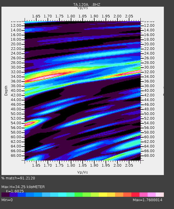
| Estimated Moho Depth: |
34.25 km |
| Estimated Crust Vp/Vs: |
1.68 |
| Assumed Crust Vp: |
6.276 km/s |
| Estimated Crust Vs: |
3.73 km/s |
| Estimated Crust Poisson's Ratio: |
0.23 |
|
| Radial Match: |
91.2128 % |
| Radial Bump: |
400 |
| Transverse Match: |
71.92155 % |
| Transverse Bump: |
400 |
| SOD ConfigId: |
2648 |
| Insert Time: |
2010-03-06 23:12:23.813 +0000 |
| GWidth: |
2.5 |
| Max Bumps: |
400 |
| Tol: |
0.001 |
|
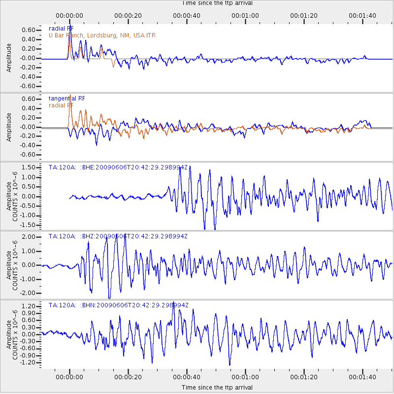
Signal To Noise
| Channel | StoN | STA | LTA |
| TA:120A: :BHZ:20090606T20:42:29.298994Z | 4.0489397 | 3.1032235E-7 | 7.664287E-8 |
| TA:120A: :BHN:20090606T20:42:29.298994Z | 0.4437178 | 1.1367713E-7 | 2.561924E-7 |
| TA:120A: :BHE:20090606T20:42:29.298994Z | 3.2209234 | 2.0346087E-7 | 6.316849E-8 |
| Arrivals |
| Ps | 3.9 SECOND |
| PpPs | 14 SECOND |
| PsPs/PpSs | 18 SECOND |


