You are here: Home > Network List > TA - USArray Transportable Network (new EarthScope stations) Stations List
> Station 120A U Bar Ranch, Lordsburg, NM, USA > Earthquake Result Viewer
120A U Bar Ranch, Lordsburg, NM, USA - Earthquake Result Viewer
| Earthquake location: |
North Of Svalbard |
| Earthquake latitude/longitude: |
80.3/-1.9 |
| Earthquake time(UTC): |
2009/03/06 (065) 10:50:29 GMT |
| Earthquake Depth: |
9.0 km |
| Earthquake Magnitude: |
6.6 MB, 6.5 MS, 6.5 MW, 6.4 MW |
| Earthquake Catalog/Contributor: |
WHDF/NEIC |
|
| Network: |
TA USArray Transportable Network (new EarthScope stations) |
| Station: |
120A U Bar Ranch, Lordsburg, NM, USA |
| Lat/Lon: |
32.55 N/108.63 W |
| Elevation: |
1528 m |
|
| Distance: |
60.9 deg |
| Az: |
292.255 deg |
| Baz: |
10.684 deg |
| Ray Param: |
0.06123424 |
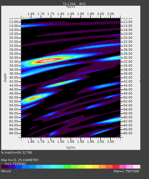
| Estimated Moho Depth: |
31.25 km |
| Estimated Crust Vp/Vs: |
1.73 |
| Assumed Crust Vp: |
6.276 km/s |
| Estimated Crust Vs: |
3.622 km/s |
| Estimated Crust Poisson's Ratio: |
0.25 |
|
| Radial Match: |
84.31798 % |
| Radial Bump: |
393 |
| Transverse Match: |
81.5248 % |
| Transverse Bump: |
400 |
| SOD ConfigId: |
2658 |
| Insert Time: |
2010-03-06 23:12:27.879 +0000 |
| GWidth: |
2.5 |
| Max Bumps: |
400 |
| Tol: |
0.001 |
|
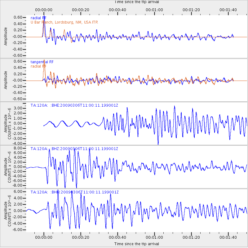
Signal To Noise
| Channel | StoN | STA | LTA |
| TA:120A: :BHZ:20090306T11:00:11.199001Z | 16.738577 | 3.5406617E-6 | 2.1152705E-7 |
| TA:120A: :BHN:20090306T11:00:11.199001Z | 4.6672635 | 2.164649E-6 | 4.6379404E-7 |
| TA:120A: :BHE:20090306T11:00:11.199001Z | 1.6366143 | 6.185349E-7 | 3.7793566E-7 |
| Arrivals |
| Ps | 3.8 SECOND |
| PpPs | 13 SECOND |
| PsPs/PpSs | 17 SECOND |


