You are here: Home > Network List > TS - TERRAscope (Southern California Seismic Network) Stations List
> Station GPO China Lake , California, USA > Earthquake Result Viewer
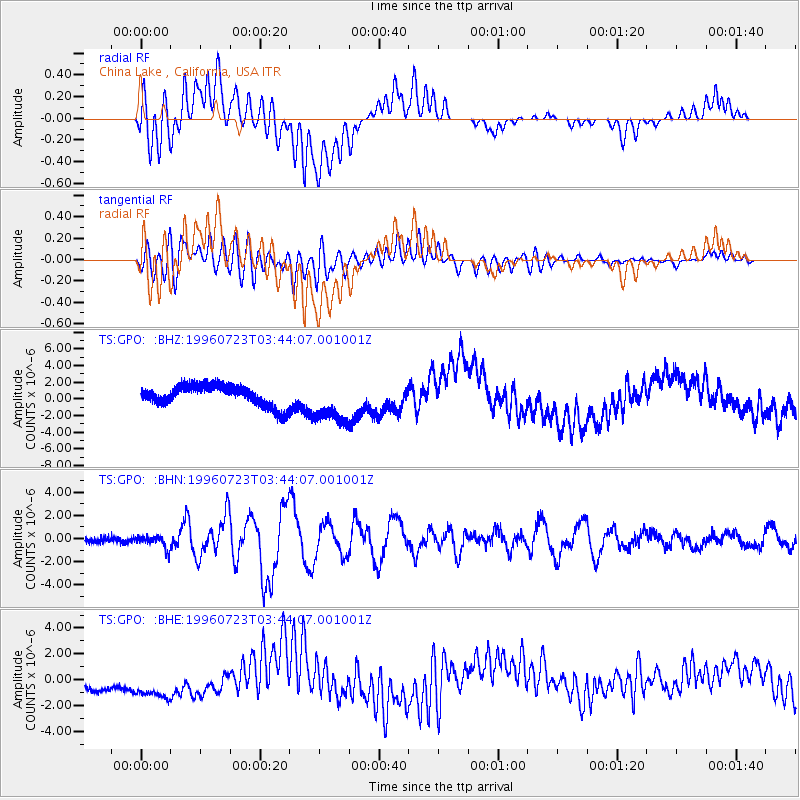
GPO China Lake , California, USA - Earthquake Result Viewer
*The percent match for this event was below the threshold and hence no stack was calculated.
| Earthquake location: |
South Of Fiji Islands |
| Earthquake latitude/longitude: |
-26.8/-177.2 |
| Earthquake time(UTC): |
1996/07/23 (205) 03:32:12 GMT |
| Earthquake Depth: |
33 km |
| Earthquake Magnitude: |
5.8 MB, 6.4 MS, 6.5 UNKNOWN, 6.5 MW |
| Earthquake Catalog/Contributor: |
WHDF/NEIC |
|
| Network: |
TS TERRAscope (Southern California Seismic Network) |
| Station: |
GPO China Lake , California, USA |
| Lat/Lon: |
35.65 N/117.66 W |
| Elevation: |
735 m |
|
| Distance: |
83.7 deg |
| Az: |
44.931 deg |
| Baz: |
230.84 deg |
| Ray Param: |
$rayparam |
*The percent match for this event was below the threshold and hence was not used in the summary stack. |
|
| Radial Match: |
14.850325 % |
| Radial Bump: |
400 |
| Transverse Match: |
50.112698 % |
| Transverse Bump: |
400 |
| SOD ConfigId: |
4480 |
| Insert Time: |
2010-02-26 14:14:44.741 +0000 |
| GWidth: |
2.5 |
| Max Bumps: |
400 |
| Tol: |
0.001 |
|
Signal To Noise
| Channel | StoN | STA | LTA |
| TS:GPO: :BHN:19960723T03:44:07.001001Z | 2.25399 | 5.392313E-7 | 2.392341E-7 |
| TS:GPO: :BHE:19960723T03:44:07.001001Z | 2.2855756 | 1.4544935E-6 | 6.3637947E-7 |
| TS:GPO: :BHZ:19960723T03:44:07.001001Z | 2.150647 | 2.6947257E-6 | 1.2529838E-6 |
| Arrivals |
| Ps | |
| PpPs | |
| PsPs/PpSs | |


