You are here: Home > Network List > TA - USArray Transportable Network (new EarthScope stations) Stations List
> Station F20K Avaraart Lake, AK, USA > Earthquake Result Viewer
F20K Avaraart Lake, AK, USA - Earthquake Result Viewer
| Earthquake location: |
Mindanao, Philippines |
| Earthquake latitude/longitude: |
6.3/126.6 |
| Earthquake time(UTC): |
2019/05/31 (151) 10:12:32 GMT |
| Earthquake Depth: |
90 km |
| Earthquake Magnitude: |
6.1 Mww |
| Earthquake Catalog/Contributor: |
NEIC PDE/us |
|
| Network: |
TA USArray Transportable Network (new EarthScope stations) |
| Station: |
F20K Avaraart Lake, AK, USA |
| Lat/Lon: |
67.05 N/155.73 W |
| Elevation: |
136 m |
|
| Distance: |
79.5 deg |
| Az: |
22.94 deg |
| Baz: |
261.11 deg |
| Ray Param: |
0.048735633 |
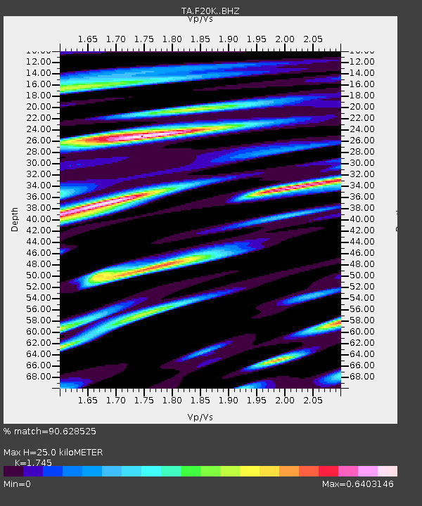
| Estimated Moho Depth: |
25.0 km |
| Estimated Crust Vp/Vs: |
1.75 |
| Assumed Crust Vp: |
6.522 km/s |
| Estimated Crust Vs: |
3.737 km/s |
| Estimated Crust Poisson's Ratio: |
0.26 |
|
| Radial Match: |
90.628525 % |
| Radial Bump: |
400 |
| Transverse Match: |
79.07947 % |
| Transverse Bump: |
400 |
| SOD ConfigId: |
18369291 |
| Insert Time: |
2019-06-14 10:16:42.703 +0000 |
| GWidth: |
2.5 |
| Max Bumps: |
400 |
| Tol: |
0.001 |
|

Signal To Noise
| Channel | StoN | STA | LTA |
| TA:F20K: :BHZ:20190531T10:23:57.74999Z | 9.392064 | 5.7807245E-7 | 6.154903E-8 |
| TA:F20K: :BHN:20190531T10:23:57.74999Z | 2.0165462 | 1.0731756E-7 | 5.32185E-8 |
| TA:F20K: :BHE:20190531T10:23:57.74999Z | 4.676838 | 2.6678543E-7 | 5.7043977E-8 |
| Arrivals |
| Ps | 2.9 SECOND |
| PpPs | 10 SECOND |
| PsPs/PpSs | 13 SECOND |


