You are here: Home > Network List > TA - USArray Transportable Network (new EarthScope stations) Stations List
> Station G23K Bananza Creek, AK, USA > Earthquake Result Viewer
G23K Bananza Creek, AK, USA - Earthquake Result Viewer
| Earthquake location: |
Mindanao, Philippines |
| Earthquake latitude/longitude: |
6.3/126.6 |
| Earthquake time(UTC): |
2019/05/31 (151) 10:12:32 GMT |
| Earthquake Depth: |
90 km |
| Earthquake Magnitude: |
6.1 Mww |
| Earthquake Catalog/Contributor: |
NEIC PDE/us |
|
| Network: |
TA USArray Transportable Network (new EarthScope stations) |
| Station: |
G23K Bananza Creek, AK, USA |
| Lat/Lon: |
66.71 N/150.02 W |
| Elevation: |
746 m |
|
| Distance: |
81.7 deg |
| Az: |
23.528 deg |
| Baz: |
266.445 deg |
| Ray Param: |
0.04722205 |
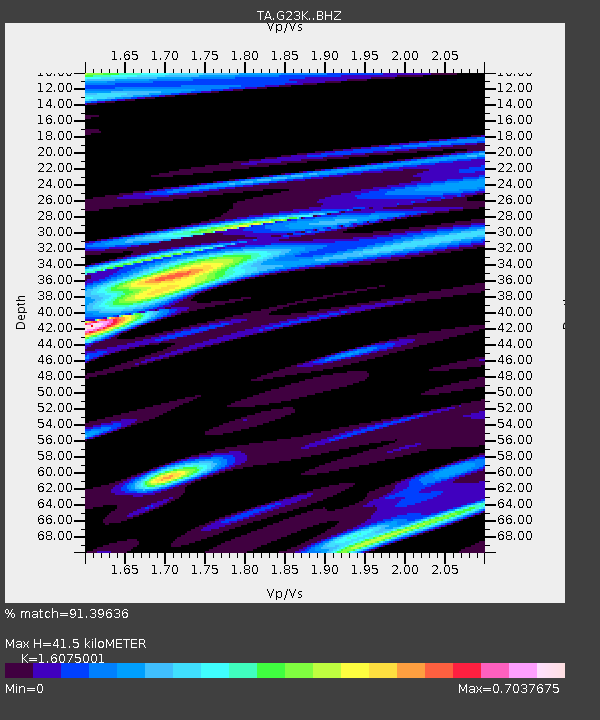
| Estimated Moho Depth: |
41.5 km |
| Estimated Crust Vp/Vs: |
1.61 |
| Assumed Crust Vp: |
6.577 km/s |
| Estimated Crust Vs: |
4.091 km/s |
| Estimated Crust Poisson's Ratio: |
0.18 |
|
| Radial Match: |
91.39636 % |
| Radial Bump: |
400 |
| Transverse Match: |
74.75385 % |
| Transverse Bump: |
400 |
| SOD ConfigId: |
18369291 |
| Insert Time: |
2019-06-14 10:16:51.287 +0000 |
| GWidth: |
2.5 |
| Max Bumps: |
400 |
| Tol: |
0.001 |
|
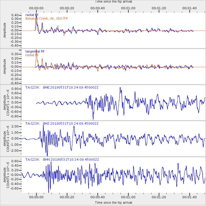
Signal To Noise
| Channel | StoN | STA | LTA |
| TA:G23K: :BHZ:20190531T10:24:09.450002Z | 10.465849 | 7.17546E-7 | 6.85607E-8 |
| TA:G23K: :BHN:20190531T10:24:09.450002Z | 0.80758595 | 5.2911908E-8 | 6.5518606E-8 |
| TA:G23K: :BHE:20190531T10:24:09.450002Z | 2.5964253 | 1.7059936E-7 | 6.570548E-8 |
| Arrivals |
| Ps | 4.0 SECOND |
| PpPs | 16 SECOND |
| PsPs/PpSs | 20 SECOND |


