You are here: Home > Network List > TS - TERRAscope (Southern California Seismic Network) Stations List
> Station GPO China Lake , California, USA > Earthquake Result Viewer
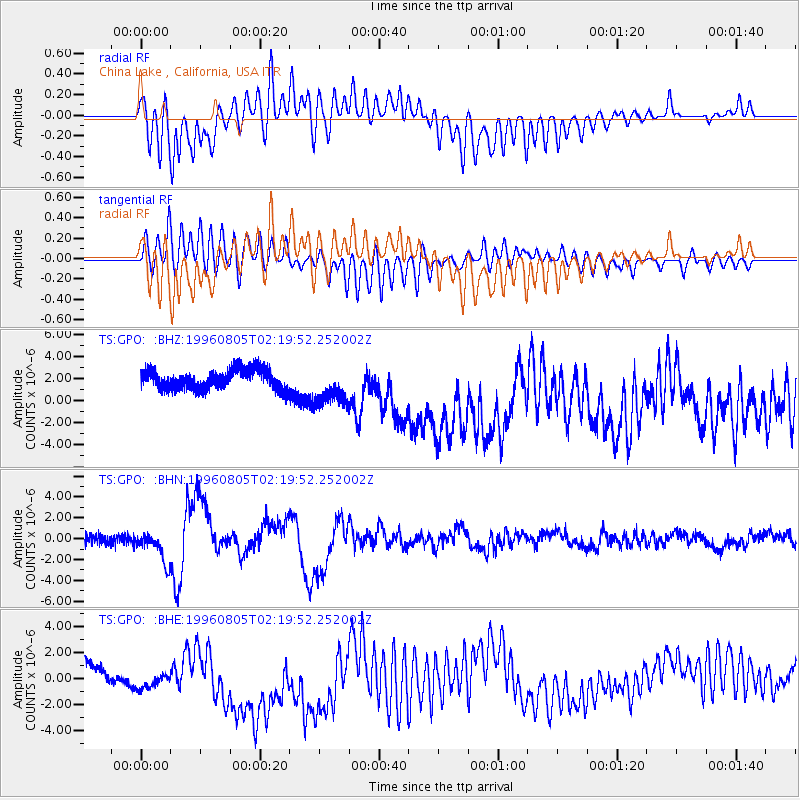
GPO China Lake , California, USA - Earthquake Result Viewer
*The percent match for this event was below the threshold and hence no stack was calculated.
| Earthquake location: |
Tonga Islands |
| Earthquake latitude/longitude: |
-15.3/-173.1 |
| Earthquake time(UTC): |
1996/08/05 (218) 02:08:58 GMT |
| Earthquake Depth: |
41 km |
| Earthquake Magnitude: |
6.0 MB, 6.7 MS, 6.7 UNKNOWN, 6.2 ME |
| Earthquake Catalog/Contributor: |
WHDF/NEIC |
|
| Network: |
TS TERRAscope (Southern California Seismic Network) |
| Station: |
GPO China Lake , California, USA |
| Lat/Lon: |
35.65 N/117.66 W |
| Elevation: |
735 m |
|
| Distance: |
72.9 deg |
| Az: |
44.579 deg |
| Baz: |
236.282 deg |
| Ray Param: |
$rayparam |
*The percent match for this event was below the threshold and hence was not used in the summary stack. |
|
| Radial Match: |
52.19958 % |
| Radial Bump: |
400 |
| Transverse Match: |
74.32115 % |
| Transverse Bump: |
400 |
| SOD ConfigId: |
4480 |
| Insert Time: |
2010-02-26 14:14:45.220 +0000 |
| GWidth: |
2.5 |
| Max Bumps: |
400 |
| Tol: |
0.001 |
|
Signal To Noise
| Channel | StoN | STA | LTA |
| TS:GPO: :BHN:19960805T02:19:52.252002Z | 3.0245109 | 1.4620999E-6 | 4.83417E-7 |
| TS:GPO: :BHE:19960805T02:19:52.252002Z | 1.6633964 | 1.5899002E-6 | 9.558156E-7 |
| TS:GPO: :BHZ:19960805T02:19:52.252002Z | 2.0047462 | 1.8164985E-6 | 9.06099E-7 |
| Arrivals |
| Ps | |
| PpPs | |
| PsPs/PpSs | |


