You are here: Home > Network List > TA - USArray Transportable Network (new EarthScope stations) Stations List
> Station 120A U Bar Ranch, Lordsburg, NM, USA > Earthquake Result Viewer
120A U Bar Ranch, Lordsburg, NM, USA - Earthquake Result Viewer
| Earthquake location: |
Northern Algeria |
| Earthquake latitude/longitude: |
35.9/-0.7 |
| Earthquake time(UTC): |
2008/06/06 (158) 20:02:56 GMT |
| Earthquake Depth: |
4.0 km |
| Earthquake Magnitude: |
5.5 MB, 5.3 MS, 5.5 MW, 5.5 MW |
| Earthquake Catalog/Contributor: |
WHDF/NEIC |
|
| Network: |
TA USArray Transportable Network (new EarthScope stations) |
| Station: |
120A U Bar Ranch, Lordsburg, NM, USA |
| Lat/Lon: |
32.55 N/108.63 W |
| Elevation: |
1528 m |
|
| Distance: |
84.2 deg |
| Az: |
306.15 deg |
| Baz: |
50.932 deg |
| Ray Param: |
0.04565023 |
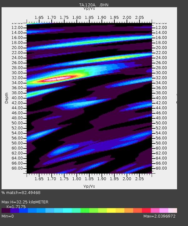
| Estimated Moho Depth: |
32.25 km |
| Estimated Crust Vp/Vs: |
1.72 |
| Assumed Crust Vp: |
6.276 km/s |
| Estimated Crust Vs: |
3.654 km/s |
| Estimated Crust Poisson's Ratio: |
0.24 |
|
| Radial Match: |
82.49468 % |
| Radial Bump: |
400 |
| Transverse Match: |
78.77598 % |
| Transverse Bump: |
400 |
| SOD ConfigId: |
2504 |
| Insert Time: |
2010-03-06 23:12:53.960 +0000 |
| GWidth: |
2.5 |
| Max Bumps: |
400 |
| Tol: |
0.001 |
|
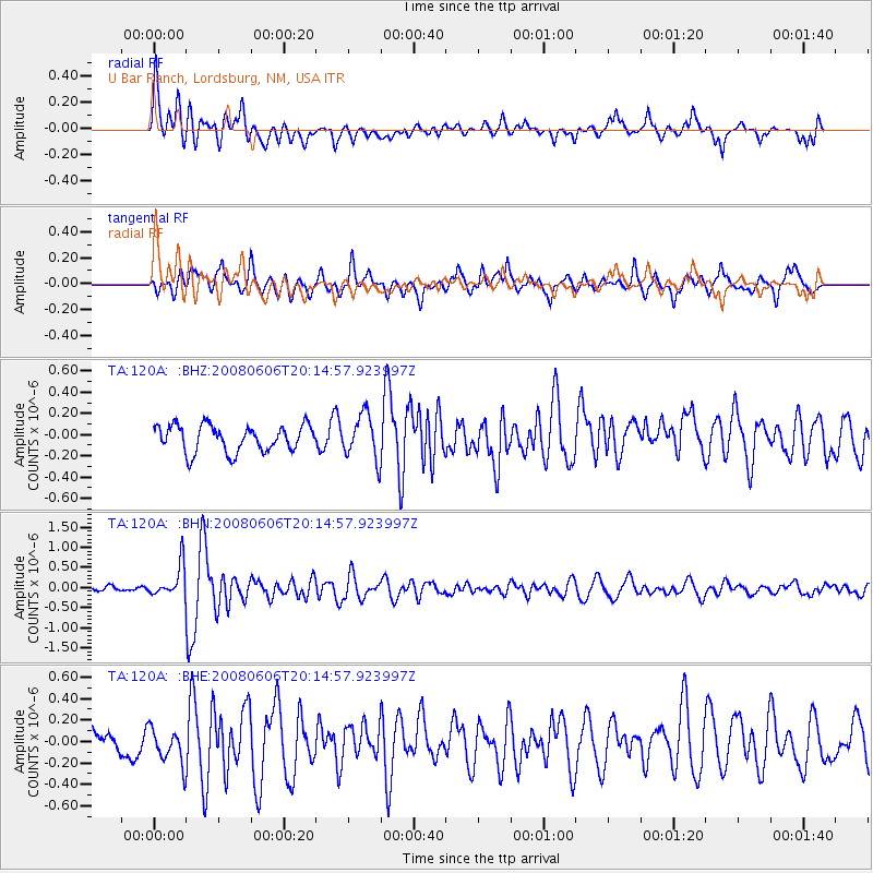
Signal To Noise
| Channel | StoN | STA | LTA |
| TA:120A: :BHN:20080606T20:14:57.923997Z | 5.319334 | 3.9912E-7 | 7.5031956E-8 |
| TA:120A: :BHE:20080606T20:14:57.923997Z | 1.76172 | 1.6872718E-7 | 9.5774126E-8 |
| TA:120A: :BHZ:20080606T20:14:57.923997Z | 1.6829782 | 2.0950401E-7 | 1.2448409E-7 |
| Arrivals |
| Ps | 3.8 SECOND |
| PpPs | 14 SECOND |
| PsPs/PpSs | 17 SECOND |


