You are here: Home > Network List > TA - USArray Transportable Network (new EarthScope stations) Stations List
> Station H17K Granite Mountain, AK, USA > Earthquake Result Viewer
H17K Granite Mountain, AK, USA - Earthquake Result Viewer
| Earthquake location: |
Mindanao, Philippines |
| Earthquake latitude/longitude: |
6.3/126.6 |
| Earthquake time(UTC): |
2019/05/31 (151) 10:12:32 GMT |
| Earthquake Depth: |
90 km |
| Earthquake Magnitude: |
6.1 Mww |
| Earthquake Catalog/Contributor: |
NEIC PDE/us |
|
| Network: |
TA USArray Transportable Network (new EarthScope stations) |
| Station: |
H17K Granite Mountain, AK, USA |
| Lat/Lon: |
64.94 N/159.91 W |
| Elevation: |
396 m |
|
| Distance: |
77.4 deg |
| Az: |
24.744 deg |
| Baz: |
257.65 deg |
| Ray Param: |
0.050143015 |
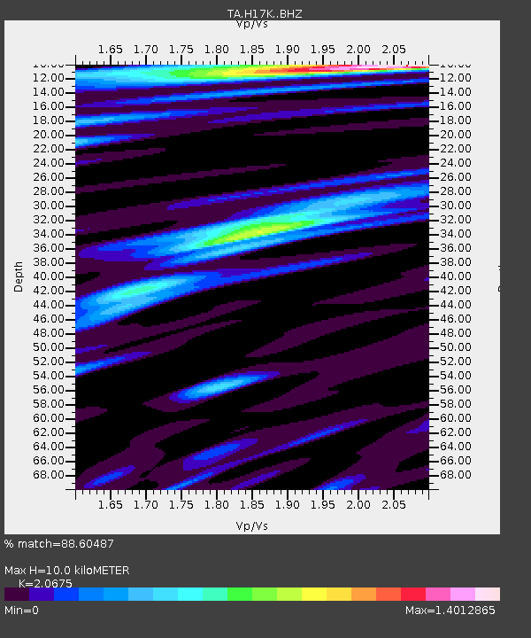
| Estimated Moho Depth: |
10.0 km |
| Estimated Crust Vp/Vs: |
2.07 |
| Assumed Crust Vp: |
6.1 km/s |
| Estimated Crust Vs: |
2.95 km/s |
| Estimated Crust Poisson's Ratio: |
0.35 |
|
| Radial Match: |
88.60487 % |
| Radial Bump: |
400 |
| Transverse Match: |
74.84361 % |
| Transverse Bump: |
400 |
| SOD ConfigId: |
18369291 |
| Insert Time: |
2019-06-14 10:16:55.203 +0000 |
| GWidth: |
2.5 |
| Max Bumps: |
400 |
| Tol: |
0.001 |
|

Signal To Noise
| Channel | StoN | STA | LTA |
| TA:H17K: :BHZ:20190531T10:23:46.37499Z | 9.839449 | 4.4146762E-7 | 4.486711E-8 |
| TA:H17K: :BHN:20190531T10:23:46.37499Z | 1.1699795 | 4.9401894E-8 | 4.222458E-8 |
| TA:H17K: :BHE:20190531T10:23:46.37499Z | 3.5690455 | 2.0540655E-7 | 5.755224E-8 |
| Arrivals |
| Ps | 1.8 SECOND |
| PpPs | 4.9 SECOND |
| PsPs/PpSs | 6.7 SECOND |


