You are here: Home > Network List > TA - USArray Transportable Network (new EarthScope stations) Stations List
> Station I17K Unalakleet, AK, USA > Earthquake Result Viewer
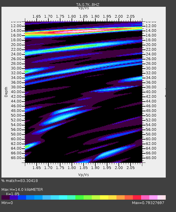
I17K Unalakleet, AK, USA - Earthquake Result Viewer
| Earthquake location: |
Mindanao, Philippines |
| Earthquake latitude/longitude: |
6.3/126.6 |
| Earthquake time(UTC): |
2019/05/31 (151) 10:12:32 GMT |
| Earthquake Depth: |
90 km |
| Earthquake Magnitude: |
6.1 Mww |
| Earthquake Catalog/Contributor: |
NEIC PDE/us |
|
| Network: |
TA USArray Transportable Network (new EarthScope stations) |
| Station: |
I17K Unalakleet, AK, USA |
| Lat/Lon: |
63.89 N/160.70 W |
| Elevation: |
105 m |
|
| Distance: |
76.8 deg |
| Az: |
25.724 deg |
| Baz: |
257.163 deg |
| Ray Param: |
0.050521985 |
| Estimated Moho Depth: |
14.0 km |
| Estimated Crust Vp/Vs: |
1.85 |
| Assumed Crust Vp: |
6.276 km/s |
| Estimated Crust Vs: |
3.392 km/s |
| Estimated Crust Poisson's Ratio: |
0.29 |
|
| Radial Match: |
83.30418 % |
| Radial Bump: |
400 |
| Transverse Match: |
70.8986 % |
| Transverse Bump: |
400 |
| SOD ConfigId: |
18369291 |
| Insert Time: |
2019-06-14 10:17:03.131 +0000 |
| GWidth: |
2.5 |
| Max Bumps: |
400 |
| Tol: |
0.001 |
|

Signal To Noise
| Channel | StoN | STA | LTA |
| TA:I17K: :BHZ:20190531T10:23:43.24999Z | 6.818097 | 4.553263E-7 | 6.678202E-8 |
| TA:I17K: :BHN:20190531T10:23:43.24999Z | 1.0445896 | 1.1225041E-7 | 1.0745886E-7 |
| TA:I17K: :BHE:20190531T10:23:43.24999Z | 1.5364811 | 1.8059127E-7 | 1.1753563E-7 |
| Arrivals |
| Ps | 2.0 SECOND |
| PpPs | 6.2 SECOND |
| PsPs/PpSs | 8.1 SECOND |


