You are here: Home > Network List > TA - USArray Transportable Network (new EarthScope stations) Stations List
> Station K17K Iditarod, AK, USA > Earthquake Result Viewer
K17K Iditarod, AK, USA - Earthquake Result Viewer
| Earthquake location: |
Mindanao, Philippines |
| Earthquake latitude/longitude: |
6.3/126.6 |
| Earthquake time(UTC): |
2019/05/31 (151) 10:12:32 GMT |
| Earthquake Depth: |
90 km |
| Earthquake Magnitude: |
6.1 Mww |
| Earthquake Catalog/Contributor: |
NEIC PDE/us |
|
| Network: |
TA USArray Transportable Network (new EarthScope stations) |
| Station: |
K17K Iditarod, AK, USA |
| Lat/Lon: |
62.72 N/158.30 W |
| Elevation: |
339 m |
|
| Distance: |
77.7 deg |
| Az: |
27.127 deg |
| Baz: |
259.608 deg |
| Ray Param: |
0.049966116 |
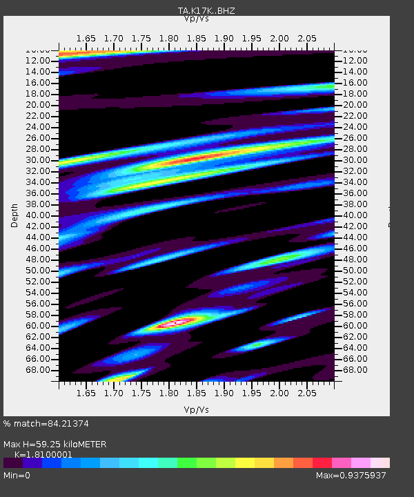
| Estimated Moho Depth: |
59.25 km |
| Estimated Crust Vp/Vs: |
1.81 |
| Assumed Crust Vp: |
6.276 km/s |
| Estimated Crust Vs: |
3.467 km/s |
| Estimated Crust Poisson's Ratio: |
0.28 |
|
| Radial Match: |
84.21374 % |
| Radial Bump: |
400 |
| Transverse Match: |
78.39947 % |
| Transverse Bump: |
400 |
| SOD ConfigId: |
18369291 |
| Insert Time: |
2019-06-14 10:17:12.819 +0000 |
| GWidth: |
2.5 |
| Max Bumps: |
400 |
| Tol: |
0.001 |
|

Signal To Noise
| Channel | StoN | STA | LTA |
| TA:K17K: :BHZ:20190531T10:23:47.825002Z | 6.2350893 | 5.787501E-7 | 9.282146E-8 |
| TA:K17K: :BHN:20190531T10:23:47.825002Z | 0.90971214 | 1.2446439E-7 | 1.3681733E-7 |
| TA:K17K: :BHE:20190531T10:23:47.825002Z | 1.1727501 | 1.5861431E-7 | 1.3524988E-7 |
| Arrivals |
| Ps | 7.9 SECOND |
| PpPs | 26 SECOND |
| PsPs/PpSs | 34 SECOND |


