You are here: Home > Network List > TA - USArray Transportable Network (new EarthScope stations) Stations List
> Station 120A U Bar Ranch, Lordsburg, NM, USA > Earthquake Result Viewer
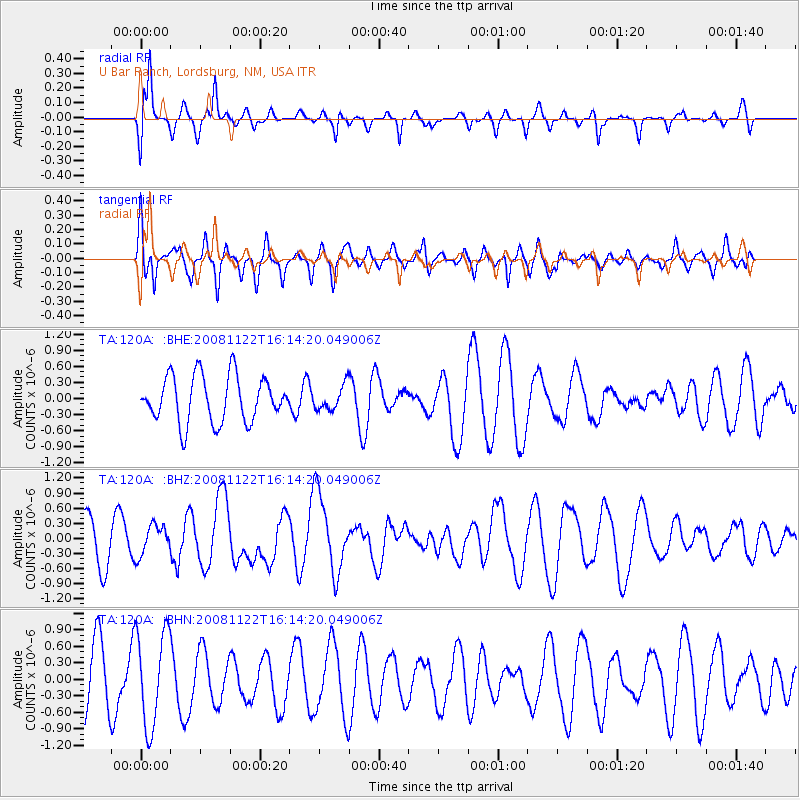
120A U Bar Ranch, Lordsburg, NM, USA - Earthquake Result Viewer
*The percent match for this event was below the threshold and hence no stack was calculated.
| Earthquake location: |
Southeast Of Loyalty Islands |
| Earthquake latitude/longitude: |
-22.5/171.2 |
| Earthquake time(UTC): |
2008/11/22 (327) 16:01:39 GMT |
| Earthquake Depth: |
57 km |
| Earthquake Magnitude: |
5.7 MB, 6.4 MW, 6.4 MW |
| Earthquake Catalog/Contributor: |
WHDF/NEIC |
|
| Network: |
TA USArray Transportable Network (new EarthScope stations) |
| Station: |
120A U Bar Ranch, Lordsburg, NM, USA |
| Lat/Lon: |
32.55 N/108.63 W |
| Elevation: |
1528 m |
|
| Distance: |
94.0 deg |
| Az: |
56.539 deg |
| Baz: |
245.969 deg |
| Ray Param: |
$rayparam |
*The percent match for this event was below the threshold and hence was not used in the summary stack. |
|
| Radial Match: |
65.954956 % |
| Radial Bump: |
287 |
| Transverse Match: |
78.65185 % |
| Transverse Bump: |
381 |
| SOD ConfigId: |
2658 |
| Insert Time: |
2010-03-06 23:13:27.741 +0000 |
| GWidth: |
2.5 |
| Max Bumps: |
400 |
| Tol: |
0.001 |
|
Signal To Noise
| Channel | StoN | STA | LTA |
| TA:120A: :BHZ:20081122T16:14:20.049006Z | 0.7449085 | 2.981097E-7 | 4.001964E-7 |
| TA:120A: :BHN:20081122T16:14:20.049006Z | 1.9527934 | 8.682708E-7 | 4.4463013E-7 |
| TA:120A: :BHE:20081122T16:14:20.049006Z | 0.5289471 | 2.2613298E-7 | 4.2751532E-7 |
| Arrivals |
| Ps | |
| PpPs | |
| PsPs/PpSs | |


