You are here: Home > Network List > TA - USArray Transportable Network (new EarthScope stations) Stations List
> Station 120A U Bar Ranch, Lordsburg, NM, USA > Earthquake Result Viewer
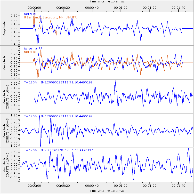
120A U Bar Ranch, Lordsburg, NM, USA - Earthquake Result Viewer
*The percent match for this event was below the threshold and hence no stack was calculated.
| Earthquake location: |
Samoa Islands Region |
| Earthquake latitude/longitude: |
-17.0/-172.1 |
| Earthquake time(UTC): |
2009/01/28 (028) 12:39:42 GMT |
| Earthquake Depth: |
10 km |
| Earthquake Magnitude: |
5.6 MB, 5.3 MS, 5.5 MW |
| Earthquake Catalog/Contributor: |
WHDF/NEIC |
|
| Network: |
TA USArray Transportable Network (new EarthScope stations) |
| Station: |
120A U Bar Ranch, Lordsburg, NM, USA |
| Lat/Lon: |
32.55 N/108.63 W |
| Elevation: |
1528 m |
|
| Distance: |
78.1 deg |
| Az: |
50.534 deg |
| Baz: |
241.014 deg |
| Ray Param: |
$rayparam |
*The percent match for this event was below the threshold and hence was not used in the summary stack. |
|
| Radial Match: |
73.26008 % |
| Radial Bump: |
400 |
| Transverse Match: |
67.44512 % |
| Transverse Bump: |
357 |
| SOD ConfigId: |
2658 |
| Insert Time: |
2010-03-06 23:14:43.035 +0000 |
| GWidth: |
2.5 |
| Max Bumps: |
400 |
| Tol: |
0.001 |
|
Signal To Noise
| Channel | StoN | STA | LTA |
| TA:120A: :BHZ:20090128T12:51:10.449019Z | 3.8697867 | 5.007881E-7 | 1.2940973E-7 |
| TA:120A: :BHN:20090128T12:51:10.449019Z | 0.88547933 | 1.349852E-7 | 1.5244308E-7 |
| TA:120A: :BHE:20090128T12:51:10.449019Z | 0.93813103 | 1.414147E-7 | 1.5074089E-7 |
| Arrivals |
| Ps | |
| PpPs | |
| PsPs/PpSs | |


