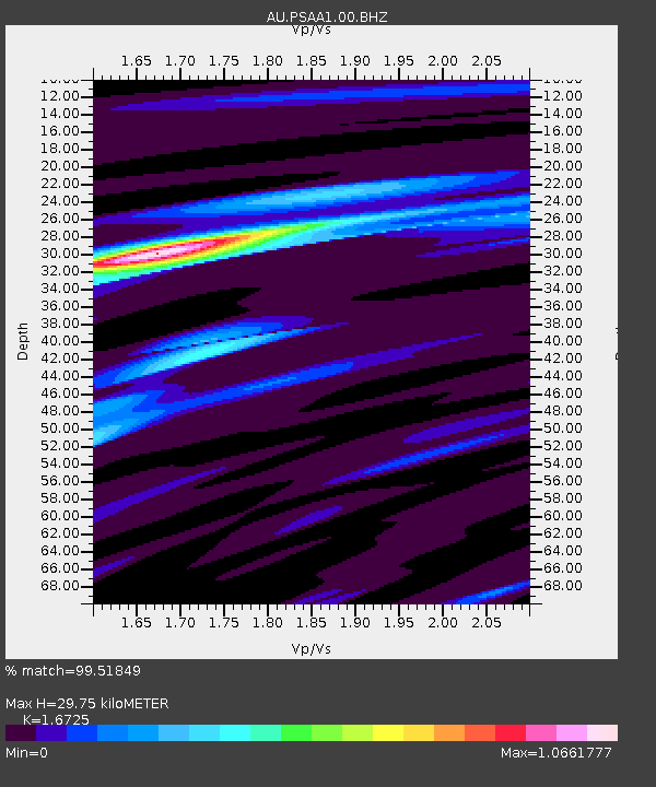
PSAA1 Pilbara Seismic Array Element A1 - Earthquake Result Viewer

Earthquake location: South Island, New Zealand
Earthquake latitude/longitude: -42.7/173.1
Earthquake time(UTC): 2016/11/13 (318) 11:02:59 GMT
Earthquake Depth: 22 km
Earthquake Magnitude: 7.8 MWW, 7.2 MWB, 7.4 MI, 7.8 MWC
Earthquake Catalog/Contributor: NEIC PDE/NEIC COMCAT
Network: AU Australian Seismological Centre
Station: PSAA1 Pilbara Seismic Array Element A1
Lat/Lon: 21.58 S/119.84 E
Elevation: 325 m
Distance: 48.9 deg
Az: 278.186 deg
Baz: 128.406 deg
Ray Param: 0.06903956
Estimated Moho Depth: 29.75 km
Estimated Crust Vp/Vs: 1.67
Assumed Crust Vp: 6.464 km/s
Estimated Crust Vs: 3.865 km/s
Estimated Crust Poisson's Ratio: 0.22
Radial Match: 99.51849 %
Radial Bump: 236
Transverse Match: 90.248314 %
Transverse Bump: 400
SOD ConfigId: 1858631
Insert Time: 2016-11-28 15:53:37.172 +0000
GWidth: 2.5
Max Bumps: 400
Tol: 0.001

Signal To Noise

ChannelStoNSTALTA
AU:PSAA1:00:BHZ:20161113T11:11:12.144005Z5.26317641.4062487E-62.6718632E-7
AU:PSAA1:00:BH1:20161113T11:11:12.144005Z3.80205976.6361326E-71.7454046E-7
AU:PSAA1:00:BH2:20161113T11:11:12.144005Z3.39071667.0719693E-72.0856857E-7
Arrivals
Ps3.3 SECOND
PpPs12 SECOND
PsPs/PpSs15 SECOND