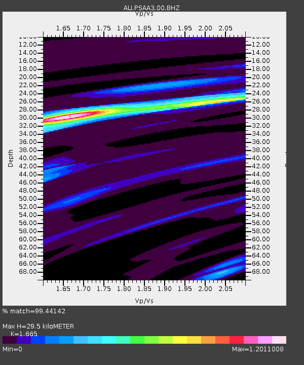
PSAA3 Pilbara Seismic Array Element A3 - Earthquake Result Viewer

Earthquake location: South Island, New Zealand
Earthquake latitude/longitude: -42.7/173.1
Earthquake time(UTC): 2016/11/13 (318) 11:02:59 GMT
Earthquake Depth: 22 km
Earthquake Magnitude: 7.8 MWW, 7.2 MWB, 7.4 MI, 7.8 MWC
Earthquake Catalog/Contributor: NEIC PDE/NEIC COMCAT
Network: AU Australian Seismological Centre
Station: PSAA3 Pilbara Seismic Array Element A3
Lat/Lon: 21.58 S/119.85 E
Elevation: 315 m
Distance: 48.9 deg
Az: 278.199 deg
Baz: 128.407 deg
Ray Param: 0.06904923
Estimated Moho Depth: 29.5 km
Estimated Crust Vp/Vs: 1.66
Assumed Crust Vp: 6.464 km/s
Estimated Crust Vs: 3.882 km/s
Estimated Crust Poisson's Ratio: 0.22
Radial Match: 99.44142 %
Radial Bump: 243
Transverse Match: 89.3915 %
Transverse Bump: 400
SOD ConfigId: 1858631
Insert Time: 2016-11-28 15:53:39.920 +0000
GWidth: 2.5
Max Bumps: 400
Tol: 0.001

Signal To Noise

ChannelStoNSTALTA
AU:PSAA3:00:BHZ:20161113T11:11:12.043999Z4.67155551.4553252E-63.1152905E-7
AU:PSAA3:00:BH1:20161113T11:11:12.043999Z3.03994236.229398E-72.0491831E-7
AU:PSAA3:00:BH2:20161113T11:11:12.043999Z3.0423987.4948366E-72.4634633E-7
Arrivals
Ps3.2 SECOND
PpPs11 SECOND
PsPs/PpSs15 SECOND