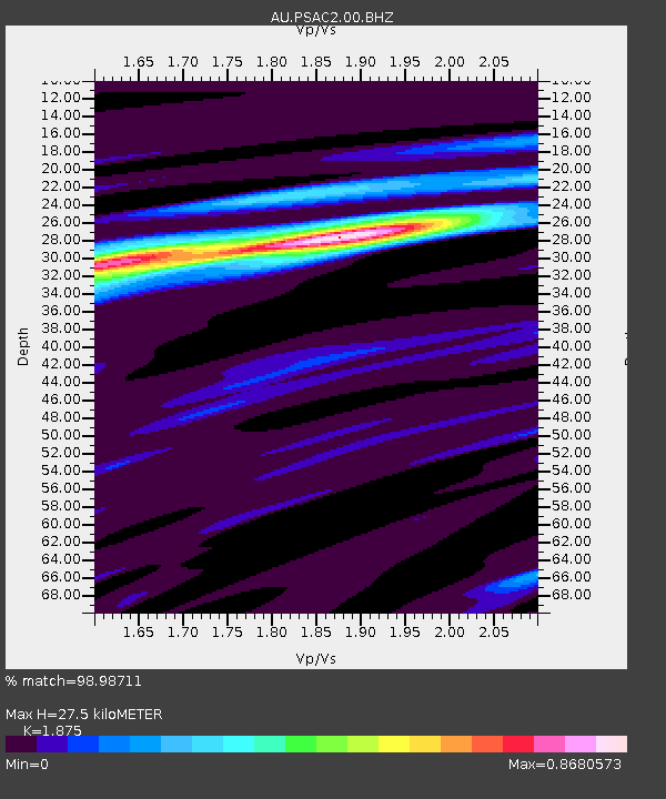
PSAC2 Pilbara Seismic Array Element C2 - Earthquake Result Viewer

Earthquake location: South Island, New Zealand
Earthquake latitude/longitude: -42.7/173.1
Earthquake time(UTC): 2016/11/13 (318) 11:02:59 GMT
Earthquake Depth: 22 km
Earthquake Magnitude: 7.8 MWW, 7.2 MWB, 7.4 MI, 7.8 MWC
Earthquake Catalog/Contributor: NEIC PDE/NEIC COMCAT
Network: AU Australian Seismological Centre
Station: PSAC2 Pilbara Seismic Array Element C2
Lat/Lon: 21.56 S/119.90 E
Elevation: 330 m
Distance: 48.8 deg
Az: 278.25 deg
Baz: 128.424 deg
Ray Param: 0.06906501
Estimated Moho Depth: 27.5 km
Estimated Crust Vp/Vs: 1.88
Assumed Crust Vp: 6.464 km/s
Estimated Crust Vs: 3.447 km/s
Estimated Crust Poisson's Ratio: 0.30
Radial Match: 98.98711 %
Radial Bump: 318
Transverse Match: 93.46638 %
Transverse Bump: 400
SOD ConfigId: 1858631
Insert Time: 2016-11-28 15:53:54.622 +0000
GWidth: 2.5
Max Bumps: 400
Tol: 0.001

Signal To Noise

ChannelStoNSTALTA
AU:PSAC2:00:BHZ:20161113T11:11:11.869011Z3.95316391.5656482E-63.960494E-7
AU:PSAC2:00:BH1:20161113T11:11:11.869011Z3.18366464.723958E-61.4838115E-6
AU:PSAC2:00:BH2:20161113T11:11:11.869011Z1.9415091.0412749E-65.363225E-7
Arrivals
Ps3.9 SECOND
PpPs12 SECOND
PsPs/PpSs15 SECOND