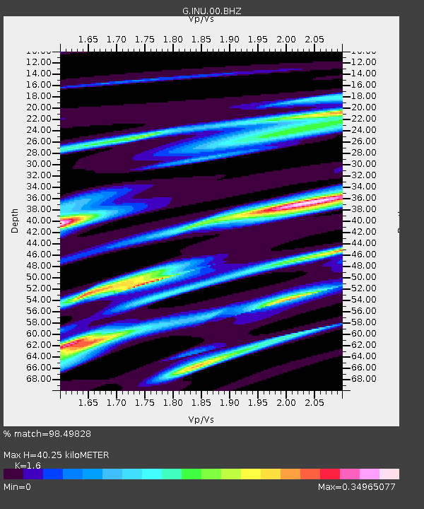
INU Inuyama, Japan - Earthquake Result Viewer
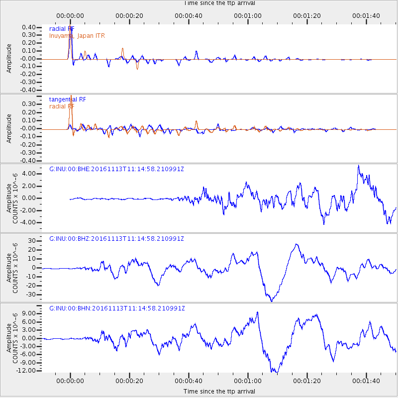
Earthquake location: South Island, New Zealand
Earthquake latitude/longitude: -42.7/173.1
Earthquake time(UTC): 2016/11/13 (318) 11:02:59 GMT
Earthquake Depth: 22 km
Earthquake Magnitude: 7.8 MWW, 7.2 MWB, 7.4 MI, 7.8 MWC
Earthquake Catalog/Contributor: NEIC PDE/NEIC COMCAT
Network: G GEOSCOPE
Station: INU Inuyama, Japan
Lat/Lon: 35.35 N/137.03 E
Elevation: 132 m
Distance: 84.4 deg
Az: 331.105 deg
Baz: 154.178 deg
Ray Param: 0.045495193
Estimated Moho Depth: 40.25 km
Estimated Crust Vp/Vs: 1.60
Assumed Crust Vp: 6.461 km/s
Estimated Crust Vs: 4.038 km/s
Estimated Crust Poisson's Ratio: 0.18
Radial Match: 98.49828 %
Radial Bump: 325
Transverse Match: 90.199005 %
Transverse Bump: 400
SOD ConfigId: 1858631
Insert Time: 2016-11-28 15:54:06.665 +0000
GWidth: 2.5
Max Bumps: 400
Tol: 0.001

Signal To Noise

ChannelStoNSTALTA
G:INU:00:BHZ:20161113T11:14:58.210991Z5.12944365.4582335E-71.0640986E-7
G:INU:00:BHN:20161113T11:14:58.210991Z1.42046241.6675305E-71.173935E-7
G:INU:00:BHE:20161113T11:14:58.210991Z1.191769.110239E-87.6443584E-8
Arrivals
Ps3.8 SECOND
PpPs16 SECOND
PsPs/PpSs20 SECOND