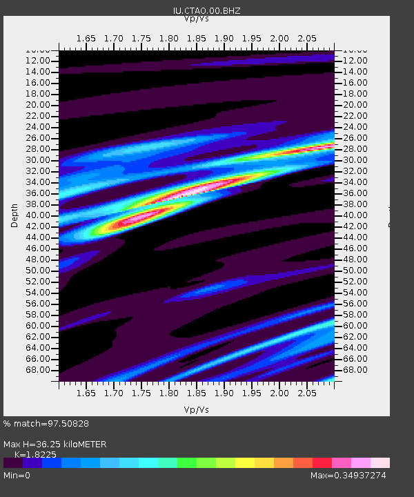
CTAO Charters Towers, Australia - Earthquake Result Viewer
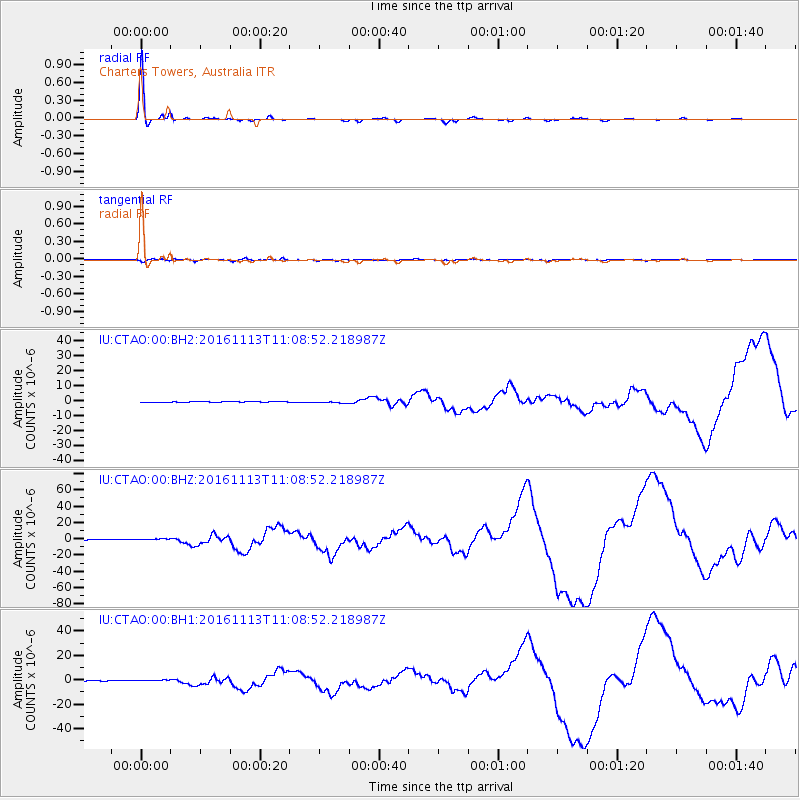
Earthquake location: South Island, New Zealand
Earthquake latitude/longitude: -42.7/173.1
Earthquake time(UTC): 2016/11/13 (318) 11:02:59 GMT
Earthquake Depth: 22 km
Earthquake Magnitude: 7.8 MWW, 7.2 MWB, 7.4 MI, 7.8 MWC
Earthquake Catalog/Contributor: NEIC PDE/NEIC COMCAT
Network: IU Global Seismograph Network (GSN - IRIS/USGS)
Station: CTAO Charters Towers, Australia
Lat/Lon: 20.09 S/146.25 E
Elevation: 357 m
Distance: 31.9 deg
Az: 306.657 deg
Baz: 141.028 deg
Ray Param: 0.07885613
Estimated Moho Depth: 36.25 km
Estimated Crust Vp/Vs: 1.82
Assumed Crust Vp: 6.522 km/s
Estimated Crust Vs: 3.578 km/s
Estimated Crust Poisson's Ratio: 0.28
Radial Match: 97.50828 %
Radial Bump: 228
Transverse Match: 65.746635 %
Transverse Bump: 400
SOD ConfigId: 1858631
Insert Time: 2016-11-28 15:54:27.953 +0000
GWidth: 2.5
Max Bumps: 400
Tol: 0.001

Signal To Noise

ChannelStoNSTALTA
IU:CTAO:00:BHZ:20161113T11:08:52.218987Z5.26371771.0339933E-61.9643784E-7
IU:CTAO:00:BH1:20161113T11:08:52.218987Z3.7640816.6998905E-71.7799539E-7
IU:CTAO:00:BH2:20161113T11:08:52.218987Z2.79425725.9370507E-72.1247331E-7
Arrivals
Ps5.0 SECOND
PpPs14 SECOND
PsPs/PpSs19 SECOND