You are here: Home > Network List > TA - USArray Transportable Network (new EarthScope stations) Stations List
> Station B08A Colville Reservation, Omak, WA, USA > Earthquake Result Viewer
B08A Colville Reservation, Omak, WA, USA - Earthquake Result Viewer
| Earthquake location: |
Eastern New Guinea Reg., P.N.G. |
| Earthquake latitude/longitude: |
-5.8/147.1 |
| Earthquake time(UTC): |
2007/11/22 (326) 08:48:27 GMT |
| Earthquake Depth: |
53 km |
| Earthquake Magnitude: |
6.0 MB, 6.7 MW, 6.7 MW |
| Earthquake Catalog/Contributor: |
WHDF/NEIC |
|
| Network: |
TA USArray Transportable Network (new EarthScope stations) |
| Station: |
B08A Colville Reservation, Omak, WA, USA |
| Lat/Lon: |
48.36 N/119.33 W |
| Elevation: |
696 m |
|
| Distance: |
96.6 deg |
| Az: |
42.079 deg |
| Baz: |
268.828 deg |
| Ray Param: |
0.040421464 |
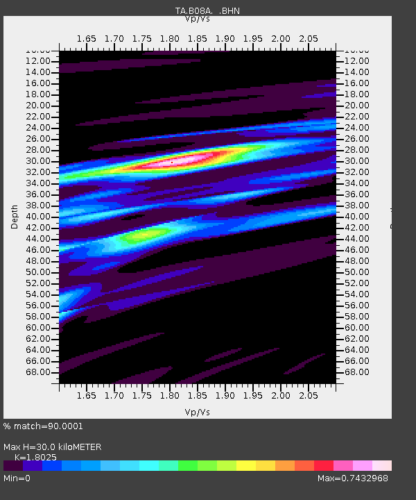
| Estimated Moho Depth: |
30.0 km |
| Estimated Crust Vp/Vs: |
1.80 |
| Assumed Crust Vp: |
6.419 km/s |
| Estimated Crust Vs: |
3.561 km/s |
| Estimated Crust Poisson's Ratio: |
0.28 |
|
| Radial Match: |
90.0001 % |
| Radial Bump: |
400 |
| Transverse Match: |
74.312096 % |
| Transverse Bump: |
400 |
| SOD ConfigId: |
2564 |
| Insert Time: |
2010-03-06 23:15:41.934 +0000 |
| GWidth: |
2.5 |
| Max Bumps: |
400 |
| Tol: |
0.001 |
|
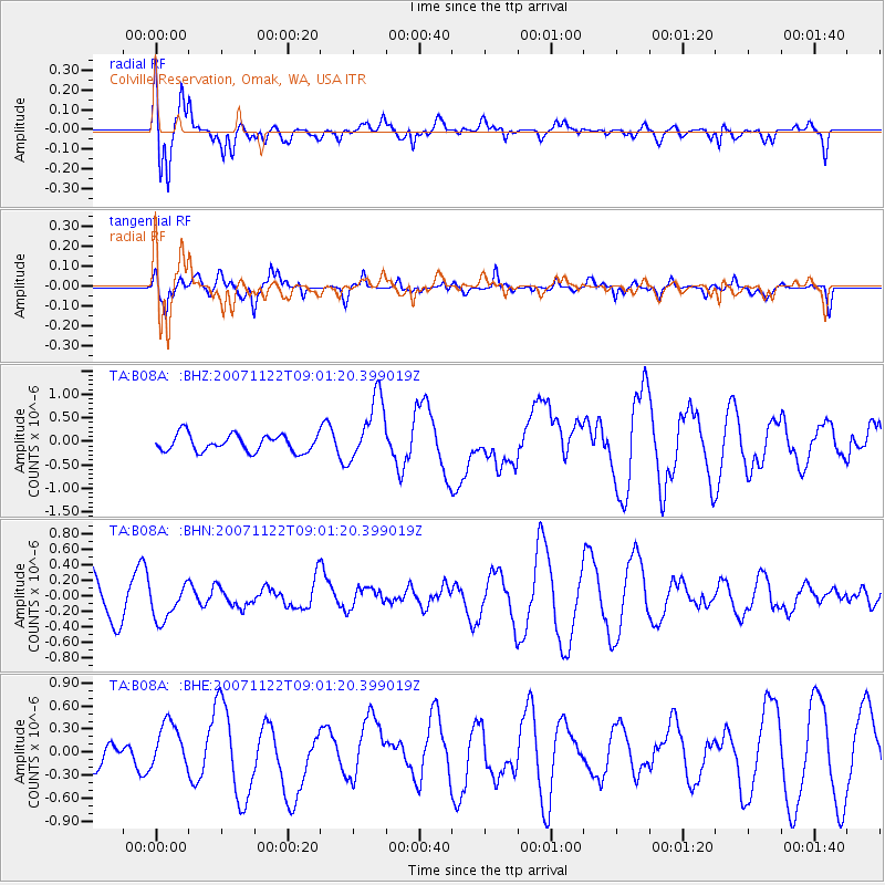
Signal To Noise
| Channel | StoN | STA | LTA |
| TA:B08A: :BHN:20071122T09:01:20.399019Z | 0.8092197 | 2.2587577E-7 | 2.7912785E-7 |
| TA:B08A: :BHE:20071122T09:01:20.399019Z | 1.4058188 | 3.002467E-7 | 2.1357427E-7 |
| TA:B08A: :BHZ:20071122T09:01:20.399019Z | 3.8091633 | 6.908019E-7 | 1.8135268E-7 |
| Arrivals |
| Ps | 3.8 SECOND |
| PpPs | 13 SECOND |
| PsPs/PpSs | 17 SECOND |


