You are here: Home > Network List > TA - USArray Transportable Network (new EarthScope stations) Stations List
> Station B08A Colville Reservation, Omak, WA, USA > Earthquake Result Viewer
B08A Colville Reservation, Omak, WA, USA - Earthquake Result Viewer
| Earthquake location: |
Mariana Islands |
| Earthquake latitude/longitude: |
18.9/145.4 |
| Earthquake time(UTC): |
2007/10/31 (304) 03:30:17 GMT |
| Earthquake Depth: |
223 km |
| Earthquake Magnitude: |
6.2 MB, 7.2 MW, 7.2 MW |
| Earthquake Catalog/Contributor: |
WHDF/NEIC |
|
| Network: |
TA USArray Transportable Network (new EarthScope stations) |
| Station: |
B08A Colville Reservation, Omak, WA, USA |
| Lat/Lon: |
48.36 N/119.33 W |
| Elevation: |
696 m |
|
| Distance: |
79.5 deg |
| Az: |
42.479 deg |
| Baz: |
286.537 deg |
| Ray Param: |
0.04832181 |
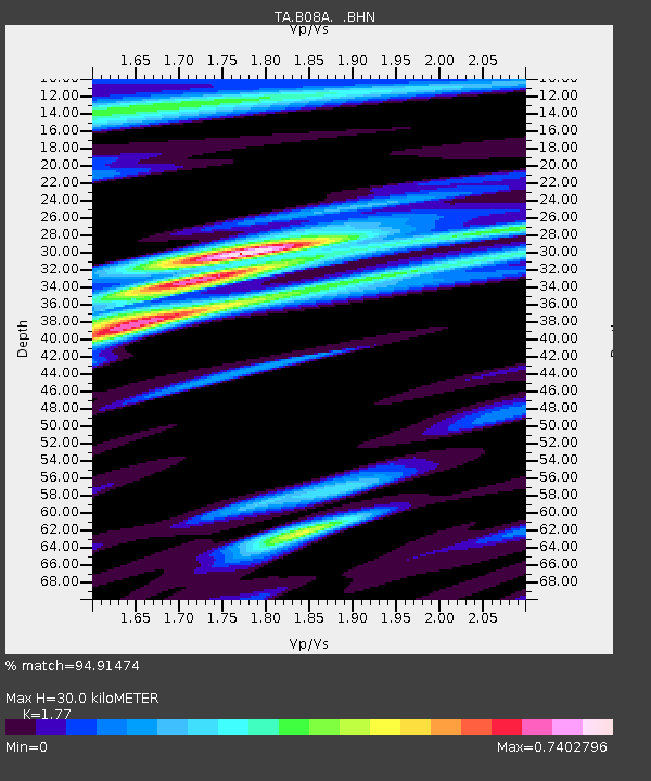
| Estimated Moho Depth: |
30.0 km |
| Estimated Crust Vp/Vs: |
1.77 |
| Assumed Crust Vp: |
6.419 km/s |
| Estimated Crust Vs: |
3.627 km/s |
| Estimated Crust Poisson's Ratio: |
0.27 |
|
| Radial Match: |
94.91474 % |
| Radial Bump: |
263 |
| Transverse Match: |
77.24804 % |
| Transverse Bump: |
400 |
| SOD ConfigId: |
2564 |
| Insert Time: |
2010-03-06 23:15:48.387 +0000 |
| GWidth: |
2.5 |
| Max Bumps: |
400 |
| Tol: |
0.001 |
|
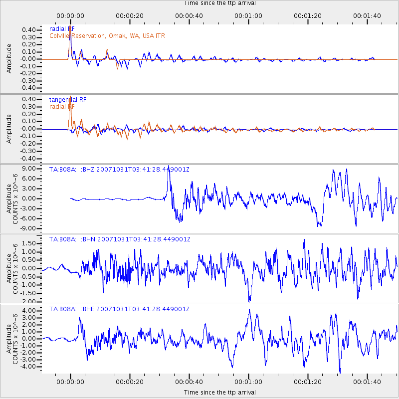
Signal To Noise
| Channel | StoN | STA | LTA |
| TA:B08A: :BHN:20071031T03:41:28.449001Z | 1.4610187 | 2.528324E-7 | 1.7305213E-7 |
| TA:B08A: :BHE:20071031T03:41:28.449001Z | 3.4399807 | 1.1914486E-6 | 3.463533E-7 |
| TA:B08A: :BHZ:20071031T03:41:28.449001Z | 23.965326 | 3.5080564E-6 | 1.463805E-7 |
| Arrivals |
| Ps | 3.7 SECOND |
| PpPs | 13 SECOND |
| PsPs/PpSs | 16 SECOND |


