You are here: Home > Network List > TA - USArray Transportable Network (new EarthScope stations) Stations List
> Station B08A Colville Reservation, Omak, WA, USA > Earthquake Result Viewer
B08A Colville Reservation, Omak, WA, USA - Earthquake Result Viewer
| Earthquake location: |
Santa Cruz Islands |
| Earthquake latitude/longitude: |
-11.6/165.8 |
| Earthquake time(UTC): |
2007/09/02 (245) 01:05:18 GMT |
| Earthquake Depth: |
35 km |
| Earthquake Magnitude: |
5.9 MB, 7.3 MS, 7.2 MW, 6.9 ME |
| Earthquake Catalog/Contributor: |
WHDF/NEIC |
|
| Network: |
TA USArray Transportable Network (new EarthScope stations) |
| Station: |
B08A Colville Reservation, Omak, WA, USA |
| Lat/Lon: |
48.36 N/119.33 W |
| Elevation: |
696 m |
|
| Distance: |
88.8 deg |
| Az: |
40.097 deg |
| Baz: |
251.122 deg |
| Ray Param: |
0.04228127 |
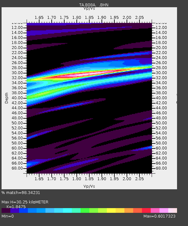
| Estimated Moho Depth: |
30.25 km |
| Estimated Crust Vp/Vs: |
1.85 |
| Assumed Crust Vp: |
6.419 km/s |
| Estimated Crust Vs: |
3.475 km/s |
| Estimated Crust Poisson's Ratio: |
0.29 |
|
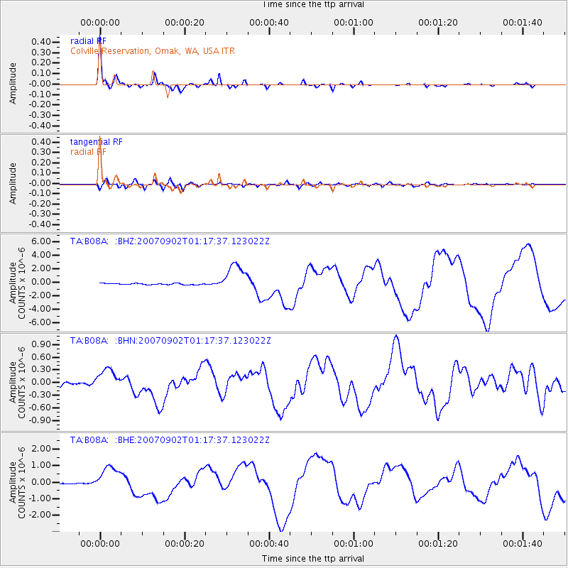
| Radial Match: |
98.34231 % |
| Radial Bump: |
242 |
| Transverse Match: |
89.68342 % |
| Transverse Bump: |
400 |
| SOD ConfigId: |
2564 |
| Insert Time: |
2010-03-06 23:16:02.038 +0000 |
| GWidth: |
2.5 |
| Max Bumps: |
400 |
| Tol: |
0.001 |
|
Signal To Noise
| Channel | StoN | STA | LTA |
| TA:B08A: :BHN:20070902T01:17:37.123022Z | 6.37642 | 2.629269E-7 | 4.123425E-8 |
| TA:B08A: :BHE:20070902T01:17:37.123022Z | 23.361671 | 7.804817E-7 | 3.340864E-8 |
| TA:B08A: :BHZ:20070902T01:17:37.123022Z | 24.726171 | 2.205652E-6 | 8.9203134E-8 |
| Arrivals |
| Ps | 4.1 SECOND |
| PpPs | 13 SECOND |
| PsPs/PpSs | 17 SECOND |


