You are here: Home > Network List > TA - USArray Transportable Network (new EarthScope stations) Stations List
> Station B08A Colville Reservation, Omak, WA, USA > Earthquake Result Viewer
B08A Colville Reservation, Omak, WA, USA - Earthquake Result Viewer
| Earthquake location: |
Near Coast Of Peru |
| Earthquake latitude/longitude: |
-13.4/-76.6 |
| Earthquake time(UTC): |
2007/08/15 (227) 23:40:57 GMT |
| Earthquake Depth: |
39 km |
| Earthquake Magnitude: |
6.7 MB, 7.9 MS, 8.0 MW, 7.5 ME |
| Earthquake Catalog/Contributor: |
WHDF/NEIC |
|
| Network: |
TA USArray Transportable Network (new EarthScope stations) |
| Station: |
B08A Colville Reservation, Omak, WA, USA |
| Lat/Lon: |
48.36 N/119.33 W |
| Elevation: |
696 m |
|
| Distance: |
72.2 deg |
| Az: |
331.623 deg |
| Baz: |
136.094 deg |
| Ray Param: |
0.053740706 |
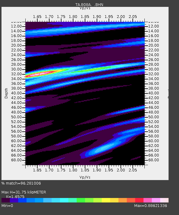
| Estimated Moho Depth: |
31.75 km |
| Estimated Crust Vp/Vs: |
1.66 |
| Assumed Crust Vp: |
6.419 km/s |
| Estimated Crust Vs: |
3.873 km/s |
| Estimated Crust Poisson's Ratio: |
0.21 |
|
| Radial Match: |
96.281006 % |
| Radial Bump: |
387 |
| Transverse Match: |
87.74839 % |
| Transverse Bump: |
400 |
| SOD ConfigId: |
2564 |
| Insert Time: |
2010-03-06 23:16:05.463 +0000 |
| GWidth: |
2.5 |
| Max Bumps: |
400 |
| Tol: |
0.001 |
|
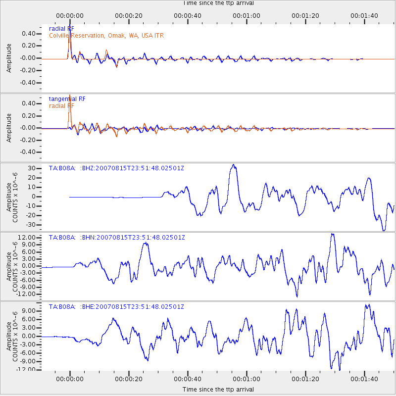
Signal To Noise
| Channel | StoN | STA | LTA |
| TA:B08A: :BHN:20070815T23:51:48.02501Z | 12.877575 | 1.0761534E-6 | 8.356802E-8 |
| TA:B08A: :BHE:20070815T23:51:48.02501Z | 13.545089 | 9.955706E-7 | 7.350049E-8 |
| TA:B08A: :BHZ:20070815T23:51:48.02501Z | 28.24029 | 3.4692405E-6 | 1.228472E-7 |
| Arrivals |
| Ps | 3.4 SECOND |
| PpPs | 13 SECOND |
| PsPs/PpSs | 16 SECOND |


