You are here: Home > Network List > IU - Global Seismograph Network (GSN - IRIS/USGS) Stations List
> Station AFI Afiamalu, Samoa > Earthquake Result Viewer
AFI Afiamalu, Samoa - Earthquake Result Viewer
| Earthquake location: |
South Island, New Zealand |
| Earthquake latitude/longitude: |
-42.4/173.7 |
| Earthquake time(UTC): |
2016/11/13 (318) 11:12:39 GMT |
| Earthquake Depth: |
10 km |
| Earthquake Magnitude: |
5.8 MB |
| Earthquake Catalog/Contributor: |
NEIC PDE/NEIC COMCAT |
|
| Network: |
IU Global Seismograph Network (GSN - IRIS/USGS) |
| Station: |
AFI Afiamalu, Samoa |
| Lat/Lon: |
13.91 S/171.78 W |
| Elevation: |
706 m |
|
| Distance: |
31.1 deg |
| Az: |
28.261 deg |
| Baz: |
201.176 deg |
| Ray Param: |
0.07917023 |
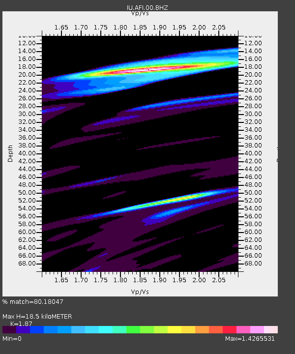
| Estimated Moho Depth: |
18.5 km |
| Estimated Crust Vp/Vs: |
1.87 |
| Assumed Crust Vp: |
4.24 km/s |
| Estimated Crust Vs: |
2.267 km/s |
| Estimated Crust Poisson's Ratio: |
0.30 |
|
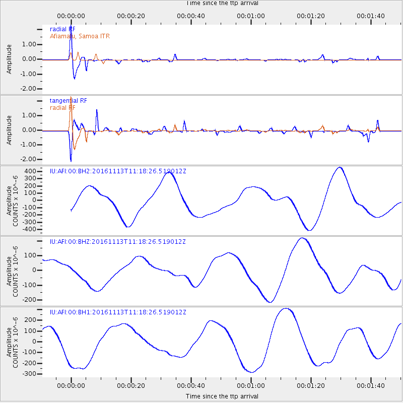
| Radial Match: |
80.18047 % |
| Radial Bump: |
400 |
| Transverse Match: |
70.814766 % |
| Transverse Bump: |
373 |
| SOD ConfigId: |
1858631 |
| Insert Time: |
2016-11-28 15:55:35.745 +0000 |
| GWidth: |
2.5 |
| Max Bumps: |
400 |
| Tol: |
0.001 |
|
Signal To Noise
| Channel | StoN | STA | LTA |
| IU:AFI:00:BHZ:20161113T11:18:26.519012Z | 0.5121041 | 3.908746E-5 | 7.6327175E-5 |
| IU:AFI:00:BH1:20161113T11:18:26.519012Z | 5.0514264 | 2.8074873E-4 | 5.557811E-5 |
| IU:AFI:00:BH2:20161113T11:18:26.519012Z | 2.1404986 | 3.7336766E-4 | 1.7443023E-4 |
| Arrivals |
| Ps | 3.9 SECOND |
| PpPs | 12 SECOND |
| PsPs/PpSs | 16 SECOND |


