You are here: Home > Network List > TA - USArray Transportable Network (new EarthScope stations) Stations List
> Station B08A Colville Reservation, Omak, WA, USA > Earthquake Result Viewer
B08A Colville Reservation, Omak, WA, USA - Earthquake Result Viewer
| Earthquake location: |
New Ireland Region, P.N.G. |
| Earthquake latitude/longitude: |
-3.6/151.0 |
| Earthquake time(UTC): |
2007/06/18 (169) 06:18:48 GMT |
| Earthquake Depth: |
26 km |
| Earthquake Magnitude: |
5.7 MB, 6.2 MS, 6.3 MW, 6.1 MW |
| Earthquake Catalog/Contributor: |
WHDF/NEIC |
|
| Network: |
TA USArray Transportable Network (new EarthScope stations) |
| Station: |
B08A Colville Reservation, Omak, WA, USA |
| Lat/Lon: |
48.36 N/119.33 W |
| Elevation: |
696 m |
|
| Distance: |
92.4 deg |
| Az: |
41.879 deg |
| Baz: |
267.423 deg |
| Ray Param: |
0.041449253 |
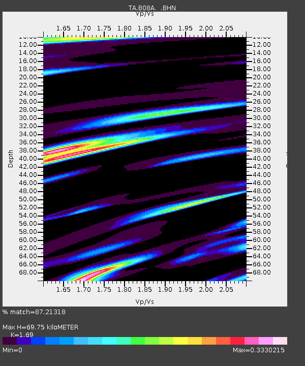
| Estimated Moho Depth: |
69.75 km |
| Estimated Crust Vp/Vs: |
1.69 |
| Assumed Crust Vp: |
6.419 km/s |
| Estimated Crust Vs: |
3.798 km/s |
| Estimated Crust Poisson's Ratio: |
0.23 |
|
| Radial Match: |
87.21318 % |
| Radial Bump: |
382 |
| Transverse Match: |
76.8603 % |
| Transverse Bump: |
400 |
| SOD ConfigId: |
2564 |
| Insert Time: |
2010-03-06 23:16:30.944 +0000 |
| GWidth: |
2.5 |
| Max Bumps: |
400 |
| Tol: |
0.001 |
|
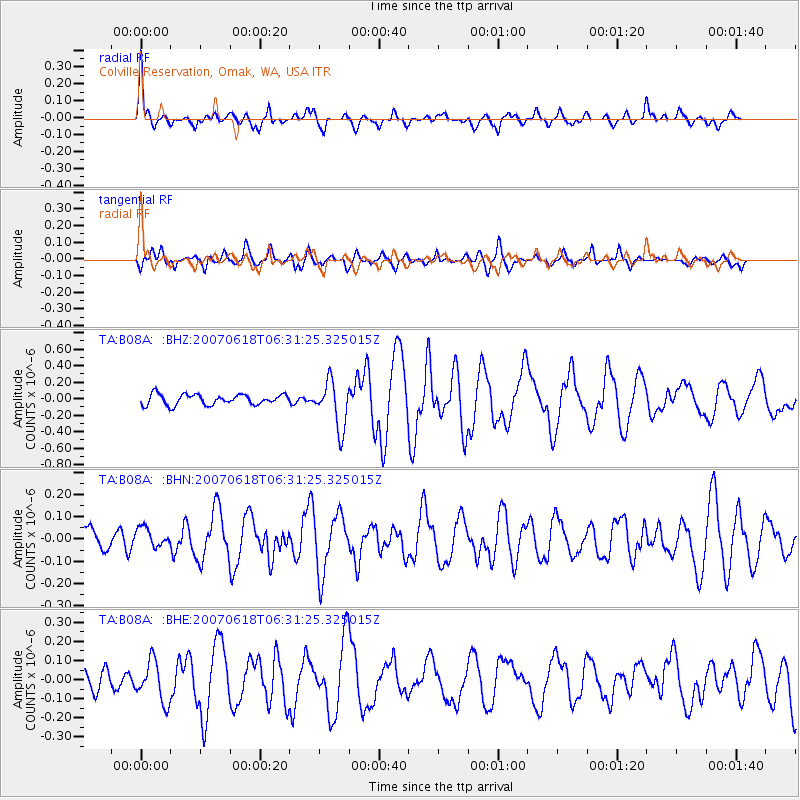
Signal To Noise
| Channel | StoN | STA | LTA |
| TA:B08A: :BHN:20070618T06:31:25.325015Z | 0.6742557 | 4.4266113E-8 | 6.565181E-8 |
| TA:B08A: :BHE:20070618T06:31:25.325015Z | 2.0821085 | 1.0695628E-7 | 5.1369216E-8 |
| TA:B08A: :BHZ:20070618T06:31:25.325015Z | 4.5223184 | 2.8438532E-7 | 6.288485E-8 |
| Arrivals |
| Ps | 7.7 SECOND |
| PpPs | 29 SECOND |
| PsPs/PpSs | 36 SECOND |


