You are here: Home > Network List > TA - USArray Transportable Network (new EarthScope stations) Stations List
> Station B08A Colville Reservation, Omak, WA, USA > Earthquake Result Viewer
B08A Colville Reservation, Omak, WA, USA - Earthquake Result Viewer
| Earthquake location: |
East Of Kuril Islands |
| Earthquake latitude/longitude: |
46.2/154.5 |
| Earthquake time(UTC): |
2007/01/13 (013) 04:23:21 GMT |
| Earthquake Depth: |
10 km |
| Earthquake Magnitude: |
7.3 MB, 8.2 MS, 8.1 MW, 7.9 MW |
| Earthquake Catalog/Contributor: |
WHDF/NEIC |
|
| Network: |
TA USArray Transportable Network (new EarthScope stations) |
| Station: |
B08A Colville Reservation, Omak, WA, USA |
| Lat/Lon: |
48.36 N/119.33 W |
| Elevation: |
696 m |
|
| Distance: |
55.4 deg |
| Az: |
53.925 deg |
| Baz: |
302.75 deg |
| Ray Param: |
0.06480566 |
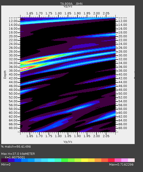
| Estimated Moho Depth: |
37.0 km |
| Estimated Crust Vp/Vs: |
1.61 |
| Assumed Crust Vp: |
6.419 km/s |
| Estimated Crust Vs: |
3.993 km/s |
| Estimated Crust Poisson's Ratio: |
0.18 |
|
| Radial Match: |
98.61496 % |
| Radial Bump: |
339 |
| Transverse Match: |
90.77786 % |
| Transverse Bump: |
400 |
| SOD ConfigId: |
2564 |
| Insert Time: |
2010-03-06 23:16:42.703 +0000 |
| GWidth: |
2.5 |
| Max Bumps: |
400 |
| Tol: |
0.001 |
|
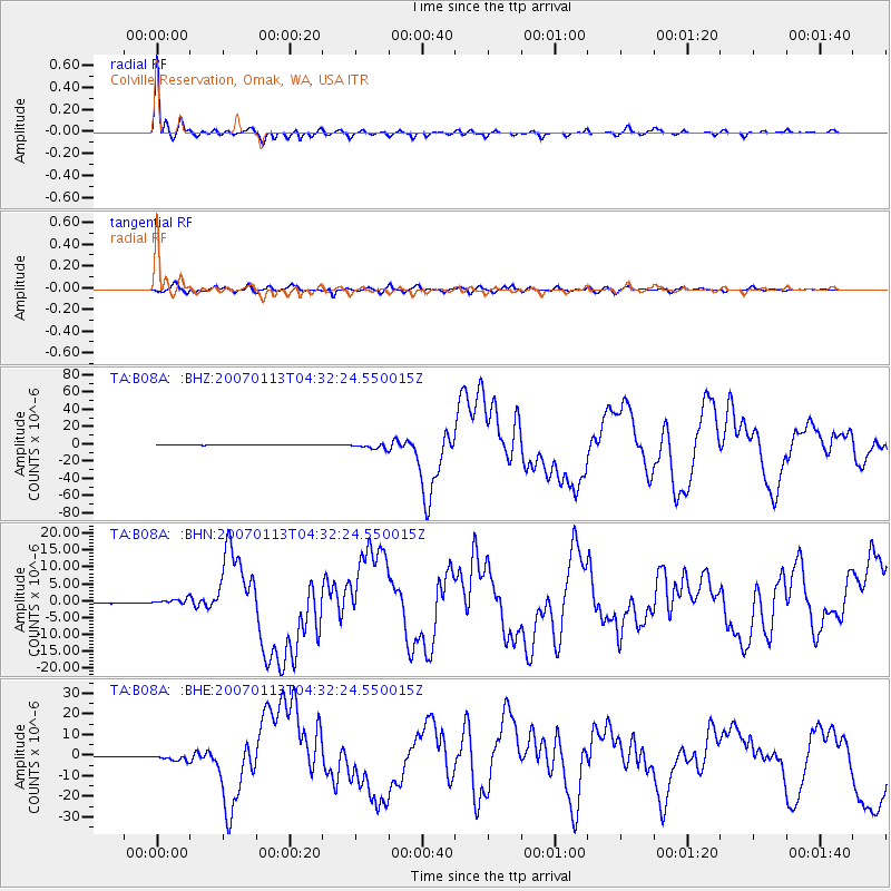
Signal To Noise
| Channel | StoN | STA | LTA |
| TA:B08A: :BHN:20070113T04:32:24.550015Z | 5.296735 | 8.4438824E-7 | 1.5941676E-7 |
| TA:B08A: :BHE:20070113T04:32:24.550015Z | 9.190337 | 1.3921779E-6 | 1.514828E-7 |
| TA:B08A: :BHZ:20070113T04:32:24.550015Z | 18.710796 | 3.0652418E-6 | 1.638221E-7 |
| Arrivals |
| Ps | 3.7 SECOND |
| PpPs | 14 SECOND |
| PsPs/PpSs | 18 SECOND |


