You are here: Home > Network List > TA - USArray Transportable Network (new EarthScope stations) Stations List
> Station O15K Ungalikthiuk River, AK, USA > Earthquake Result Viewer
O15K Ungalikthiuk River, AK, USA - Earthquake Result Viewer
| Earthquake location: |
Tonga Islands |
| Earthquake latitude/longitude: |
-21.2/-173.9 |
| Earthquake time(UTC): |
2019/06/02 (153) 10:36:29 GMT |
| Earthquake Depth: |
10 km |
| Earthquake Magnitude: |
5.9 Mww |
| Earthquake Catalog/Contributor: |
NEIC PDE/us |
|
| Network: |
TA USArray Transportable Network (new EarthScope stations) |
| Station: |
O15K Ungalikthiuk River, AK, USA |
| Lat/Lon: |
59.18 N/159.82 W |
| Elevation: |
306 m |
|
| Distance: |
80.9 deg |
| Az: |
7.282 deg |
| Baz: |
193.278 deg |
| Ray Param: |
0.04793938 |
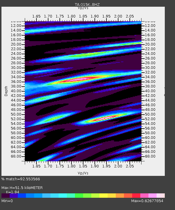
| Estimated Moho Depth: |
51.5 km |
| Estimated Crust Vp/Vs: |
1.94 |
| Assumed Crust Vp: |
6.24 km/s |
| Estimated Crust Vs: |
3.216 km/s |
| Estimated Crust Poisson's Ratio: |
0.32 |
|
| Radial Match: |
92.553566 % |
| Radial Bump: |
380 |
| Transverse Match: |
78.70821 % |
| Transverse Bump: |
400 |
| SOD ConfigId: |
18369291 |
| Insert Time: |
2019-06-16 10:41:54.107 +0000 |
| GWidth: |
2.5 |
| Max Bumps: |
400 |
| Tol: |
0.001 |
|

Signal To Noise
| Channel | StoN | STA | LTA |
| TA:O15K: :BHZ:20190602T10:48:12.375029Z | 2.7765863 | 1.6777189E-7 | 6.0423794E-8 |
| TA:O15K: :BHN:20190602T10:48:12.375029Z | 2.2438273 | 9.9827666E-8 | 4.4489905E-8 |
| TA:O15K: :BHE:20190602T10:48:12.375029Z | 0.82574856 | 4.9683933E-8 | 6.0168354E-8 |
| Arrivals |
| Ps | 7.9 SECOND |
| PpPs | 24 SECOND |
| PsPs/PpSs | 32 SECOND |


