You are here: Home > Network List > TA - USArray Transportable Network (new EarthScope stations) Stations List
> Station O17K Koliganek, Bristol Bay, AK, USA > Earthquake Result Viewer
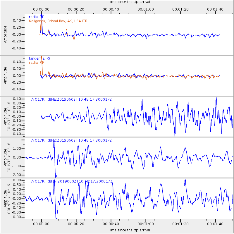
O17K Koliganek, Bristol Bay, AK, USA - Earthquake Result Viewer
| Earthquake location: |
Tonga Islands |
| Earthquake latitude/longitude: |
-21.2/-173.9 |
| Earthquake time(UTC): |
2019/06/02 (153) 10:36:29 GMT |
| Earthquake Depth: |
10 km |
| Earthquake Magnitude: |
5.9 Mww |
| Earthquake Catalog/Contributor: |
NEIC PDE/us |
|
| Network: |
TA USArray Transportable Network (new EarthScope stations) |
| Station: |
O17K Koliganek, Bristol Bay, AK, USA |
| Lat/Lon: |
59.77 N/157.09 W |
| Elevation: |
156 m |
|
| Distance: |
81.9 deg |
| Az: |
8.494 deg |
| Baz: |
195.807 deg |
| Ray Param: |
0.047286965 |
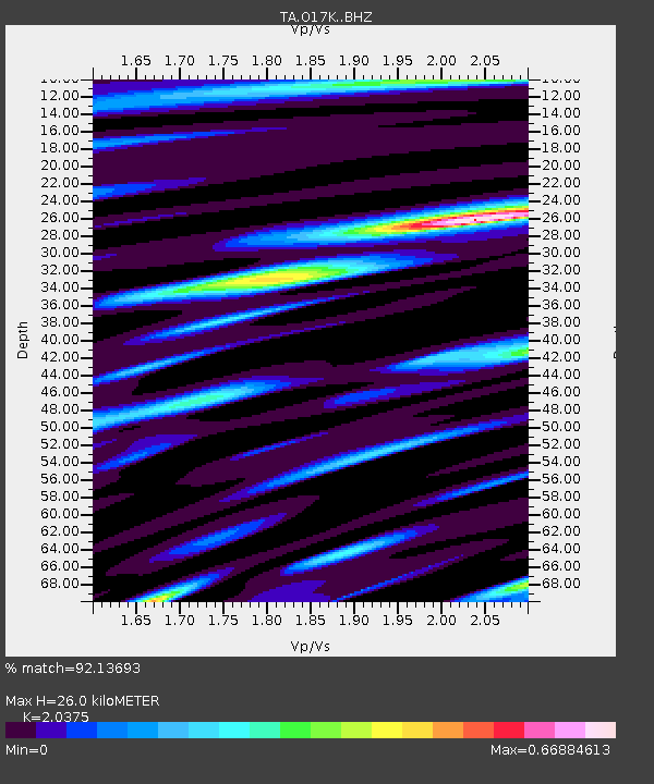
| Estimated Moho Depth: |
26.0 km |
| Estimated Crust Vp/Vs: |
2.04 |
| Assumed Crust Vp: |
6.276 km/s |
| Estimated Crust Vs: |
3.08 km/s |
| Estimated Crust Poisson's Ratio: |
0.34 |
|
| Radial Match: |
92.13693 % |
| Radial Bump: |
375 |
| Transverse Match: |
76.226295 % |
| Transverse Bump: |
400 |
| SOD ConfigId: |
18369291 |
| Insert Time: |
2019-06-16 10:41:55.146 +0000 |
| GWidth: |
2.5 |
| Max Bumps: |
400 |
| Tol: |
0.001 |
|
Signal To Noise
| Channel | StoN | STA | LTA |
| TA:O17K: :BHZ:20190602T10:48:17.300017Z | 2.9353747 | 1.923727E-7 | 6.553599E-8 |
| TA:O17K: :BHN:20190602T10:48:17.300017Z | 1.3194264 | 8.034372E-8 | 6.0892916E-8 |
| TA:O17K: :BHE:20190602T10:48:17.300017Z | 0.975748 | 4.876603E-8 | 4.9978098E-8 |
| Arrivals |
| Ps | 4.4 SECOND |
| PpPs | 12 SECOND |
| PsPs/PpSs | 17 SECOND |


