You are here: Home > Network List > US - United States National Seismic Network Stations List
> Station WMOK Wichita Mountains, Oklahoma, USA > Earthquake Result Viewer
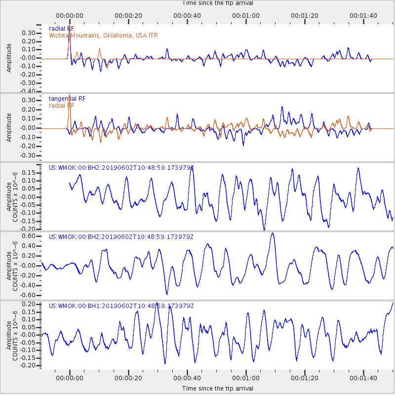
WMOK Wichita Mountains, Oklahoma, USA - Earthquake Result Viewer
*The percent match for this event was below the threshold and hence no stack was calculated.
| Earthquake location: |
Tonga Islands |
| Earthquake latitude/longitude: |
-21.2/-173.9 |
| Earthquake time(UTC): |
2019/06/02 (153) 10:36:29 GMT |
| Earthquake Depth: |
10 km |
| Earthquake Magnitude: |
5.9 Mww |
| Earthquake Catalog/Contributor: |
NEIC PDE/us |
|
| Network: |
US United States National Seismic Network |
| Station: |
WMOK Wichita Mountains, Oklahoma, USA |
| Lat/Lon: |
34.74 N/98.78 W |
| Elevation: |
486 m |
|
| Distance: |
90.4 deg |
| Az: |
52.743 deg |
| Baz: |
244.384 deg |
| Ray Param: |
$rayparam |
*The percent match for this event was below the threshold and hence was not used in the summary stack. |
|
| Radial Match: |
51.743465 % |
| Radial Bump: |
400 |
| Transverse Match: |
39.98186 % |
| Transverse Bump: |
400 |
| SOD ConfigId: |
18369291 |
| Insert Time: |
2019-06-16 10:42:39.434 +0000 |
| GWidth: |
2.5 |
| Max Bumps: |
400 |
| Tol: |
0.001 |
|
Signal To Noise
| Channel | StoN | STA | LTA |
| US:WMOK:00:BHZ:20190602T10:48:59.173979Z | 1.0533344 | 7.617193E-8 | 7.2315046E-8 |
| US:WMOK:00:BH1:20190602T10:48:59.173979Z | 0.802158 | 1.3023104E-7 | 1.6235084E-7 |
| US:WMOK:00:BH2:20190602T10:48:59.173979Z | 1.3918383 | 7.753932E-8 | 5.5710007E-8 |
| Arrivals |
| Ps | |
| PpPs | |
| PsPs/PpSs | |


