You are here: Home > Network List > II - Global Seismograph Network (GSN - IRIS/IDA) Stations List
> Station EFI Mount Kent, East Falkland Island > Earthquake Result Viewer
EFI Mount Kent, East Falkland Island - Earthquake Result Viewer
| Earthquake location: |
South Island, New Zealand |
| Earthquake latitude/longitude: |
-42.3/173.6 |
| Earthquake time(UTC): |
2016/11/13 (318) 11:32:07 GMT |
| Earthquake Depth: |
10 km |
| Earthquake Magnitude: |
6.5 MWW, 7.9 MI |
| Earthquake Catalog/Contributor: |
NEIC PDE/NEIC COMCAT |
|
| Network: |
II Global Seismograph Network (GSN - IRIS/IDA) |
| Station: |
EFI Mount Kent, East Falkland Island |
| Lat/Lon: |
51.68 S/58.06 W |
| Elevation: |
110 m |
|
| Distance: |
76.3 deg |
| Az: |
149.799 deg |
| Baz: |
216.853 deg |
| Ray Param: |
0.051119175 |
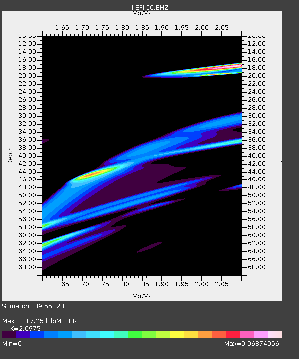
| Estimated Moho Depth: |
17.25 km |
| Estimated Crust Vp/Vs: |
2.10 |
| Assumed Crust Vp: |
6.472 km/s |
| Estimated Crust Vs: |
3.086 km/s |
| Estimated Crust Poisson's Ratio: |
0.35 |
|
| Radial Match: |
89.55128 % |
| Radial Bump: |
400 |
| Transverse Match: |
65.5751 % |
| Transverse Bump: |
400 |
| SOD ConfigId: |
1858631 |
| Insert Time: |
2016-11-28 15:56:41.956 +0000 |
| GWidth: |
2.5 |
| Max Bumps: |
400 |
| Tol: |
0.001 |
|
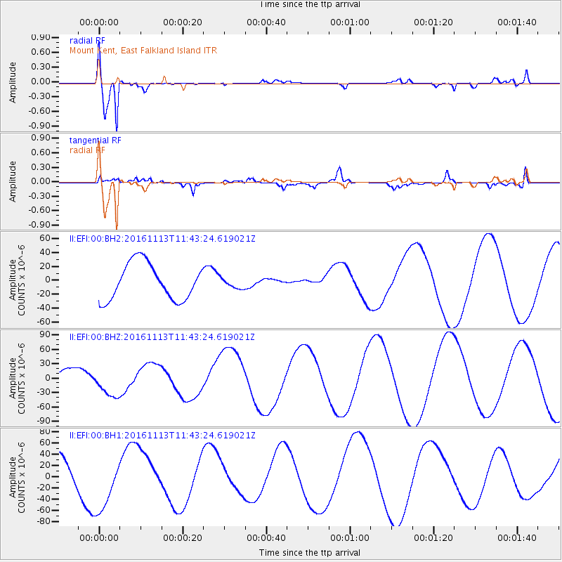
Signal To Noise
| Channel | StoN | STA | LTA |
| II:EFI:00:BHZ:20161113T11:43:24.619021Z | 2.5841634 | 3.1708856E-5 | 1.2270453E-5 |
| II:EFI:00:BH1:20161113T11:43:24.619021Z | 2.2697606 | 5.2266816E-5 | 2.3027458E-5 |
| II:EFI:00:BH2:20161113T11:43:24.619021Z | 0.27721083 | 7.220109E-6 | 2.604555E-5 |
| Arrivals |
| Ps | 3.0 SECOND |
| PpPs | 8.0 SECOND |
| PsPs/PpSs | 11 SECOND |


