You are here: Home > Network List > TA - USArray Transportable Network (new EarthScope stations) Stations List
> Station X24A Lazy VL Ranch, Encino, NM, USA > Earthquake Result Viewer
X24A Lazy VL Ranch, Encino, NM, USA - Earthquake Result Viewer
| Earthquake location: |
Central Mid-Atlantic Ridge |
| Earthquake latitude/longitude: |
8.1/-38.7 |
| Earthquake time(UTC): |
2008/09/10 (254) 13:08:14 GMT |
| Earthquake Depth: |
10 km |
| Earthquake Magnitude: |
6.3 MB, 6.5 MS, 6.6 MW, 6.6 MW |
| Earthquake Catalog/Contributor: |
WHDF/NEIC |
|
| Network: |
TA USArray Transportable Network (new EarthScope stations) |
| Station: |
X24A Lazy VL Ranch, Encino, NM, USA |
| Lat/Lon: |
34.56 N/105.43 W |
| Elevation: |
1917 m |
|
| Distance: |
66.3 deg |
| Az: |
304.118 deg |
| Baz: |
96.625 deg |
| Ray Param: |
0.057707738 |
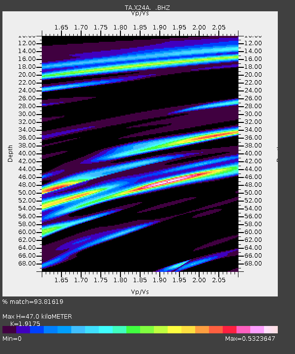
| Estimated Moho Depth: |
47.0 km |
| Estimated Crust Vp/Vs: |
1.92 |
| Assumed Crust Vp: |
6.419 km/s |
| Estimated Crust Vs: |
3.348 km/s |
| Estimated Crust Poisson's Ratio: |
0.31 |
|
| Radial Match: |
93.81619 % |
| Radial Bump: |
320 |
| Transverse Match: |
84.005226 % |
| Transverse Bump: |
400 |
| SOD ConfigId: |
2560 |
| Insert Time: |
2010-03-06 23:17:16.294 +0000 |
| GWidth: |
2.5 |
| Max Bumps: |
400 |
| Tol: |
0.001 |
|

Signal To Noise
| Channel | StoN | STA | LTA |
| TA:X24A: :BHZ:20080910T13:18:32.175015Z | 3.2404659 | 2.2982104E-7 | 7.092222E-8 |
| TA:X24A: :BHN:20080910T13:18:32.175015Z | 1.7453654 | 1.3452357E-7 | 7.707474E-8 |
| TA:X24A: :BHE:20080910T13:18:32.175015Z | 1.5016127 | 1.3971386E-7 | 9.304254E-8 |
| Arrivals |
| Ps | 7.0 SECOND |
| PpPs | 21 SECOND |
| PsPs/PpSs | 28 SECOND |


