You are here: Home > Network List > TA - USArray Transportable Network (new EarthScope stations) Stations List
> Station X24A Lazy VL Ranch, Encino, NM, USA > Earthquake Result Viewer
X24A Lazy VL Ranch, Encino, NM, USA - Earthquake Result Viewer
| Earthquake location: |
Tonga Islands |
| Earthquake latitude/longitude: |
-20.8/-174.3 |
| Earthquake time(UTC): |
2009/07/30 (211) 20:05:34 GMT |
| Earthquake Depth: |
10 km |
| Earthquake Magnitude: |
5.9 MB, 5.7 MS, 5.8 MW, 5.7 MW |
| Earthquake Catalog/Contributor: |
WHDF/NEIC |
|
| Network: |
TA USArray Transportable Network (new EarthScope stations) |
| Station: |
X24A Lazy VL Ranch, Encino, NM, USA |
| Lat/Lon: |
34.56 N/105.43 W |
| Elevation: |
1917 m |
|
| Distance: |
85.5 deg |
| Az: |
50.527 deg |
| Baz: |
241.029 deg |
| Ray Param: |
0.04474588 |
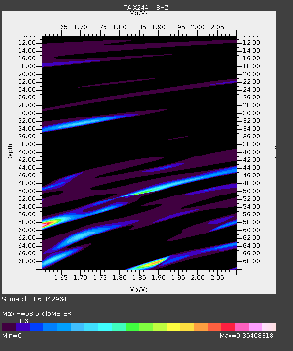
| Estimated Moho Depth: |
58.5 km |
| Estimated Crust Vp/Vs: |
1.60 |
| Assumed Crust Vp: |
6.419 km/s |
| Estimated Crust Vs: |
4.012 km/s |
| Estimated Crust Poisson's Ratio: |
0.18 |
|
| Radial Match: |
86.842964 % |
| Radial Bump: |
400 |
| Transverse Match: |
59.96788 % |
| Transverse Bump: |
400 |
| SOD ConfigId: |
2622 |
| Insert Time: |
2010-03-06 23:17:30.241 +0000 |
| GWidth: |
2.5 |
| Max Bumps: |
400 |
| Tol: |
0.001 |
|

Signal To Noise
| Channel | StoN | STA | LTA |
| TA:X24A: :BHZ:20090730T20:17:41.299021Z | 5.8578854 | 2.9187916E-7 | 4.982671E-8 |
| TA:X24A: :BHN:20090730T20:17:41.299021Z | 0.92806345 | 1.086439E-7 | 1.1706517E-7 |
| TA:X24A: :BHE:20090730T20:17:41.299021Z | 1.8928636 | 1.3435938E-7 | 7.0982075E-8 |
| Arrivals |
| Ps | 5.6 SECOND |
| PpPs | 23 SECOND |
| PsPs/PpSs | 29 SECOND |


