You are here: Home > Network List > TA - USArray Transportable Network (new EarthScope stations) Stations List
> Station B18K Kokolik River, AK, USA > Earthquake Result Viewer
B18K Kokolik River, AK, USA - Earthquake Result Viewer
*The percent match for this event was below the threshold and hence no stack was calculated.
| Earthquake location: |
Northern Sumatra, Indonesia |
| Earthquake latitude/longitude: |
0.4/97.7 |
| Earthquake time(UTC): |
2019/06/03 (154) 05:57:09 GMT |
| Earthquake Depth: |
16 km |
| Earthquake Magnitude: |
5.8 Mww |
| Earthquake Catalog/Contributor: |
NEIC PDE/us |
|
| Network: |
TA USArray Transportable Network (new EarthScope stations) |
| Station: |
B18K Kokolik River, AK, USA |
| Lat/Lon: |
69.36 N/161.80 W |
| Elevation: |
222 m |
|
| Distance: |
93.4 deg |
| Az: |
20.438 deg |
| Baz: |
279.931 deg |
| Ray Param: |
$rayparam |
*The percent match for this event was below the threshold and hence was not used in the summary stack. |
|
| Radial Match: |
68.67842 % |
| Radial Bump: |
400 |
| Transverse Match: |
69.38208 % |
| Transverse Bump: |
400 |
| SOD ConfigId: |
18369291 |
| Insert Time: |
2019-06-17 05:59:41.447 +0000 |
| GWidth: |
2.5 |
| Max Bumps: |
400 |
| Tol: |
0.001 |
|
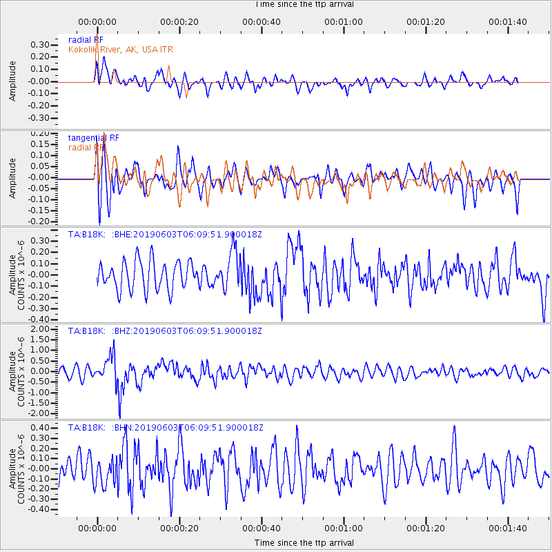
Signal To Noise
| Channel | StoN | STA | LTA |
| TA:B18K: :BHZ:20190603T06:09:51.900018Z | 3.0395405 | 6.116256E-7 | 2.0122305E-7 |
| TA:B18K: :BHN:20190603T06:09:51.900018Z | 0.9994576 | 1.281752E-7 | 1.2824476E-7 |
| TA:B18K: :BHE:20190603T06:09:51.900018Z | 1.3964831 | 1.7263746E-7 | 1.2362301E-7 |
| Arrivals |
| Ps | |
| PpPs | |
| PsPs/PpSs | |


