You are here: Home > Network List > IU - Global Seismograph Network (GSN - IRIS/USGS) Stations List
> Station POHA Pohakuloa, Hawaii, USA > Earthquake Result Viewer
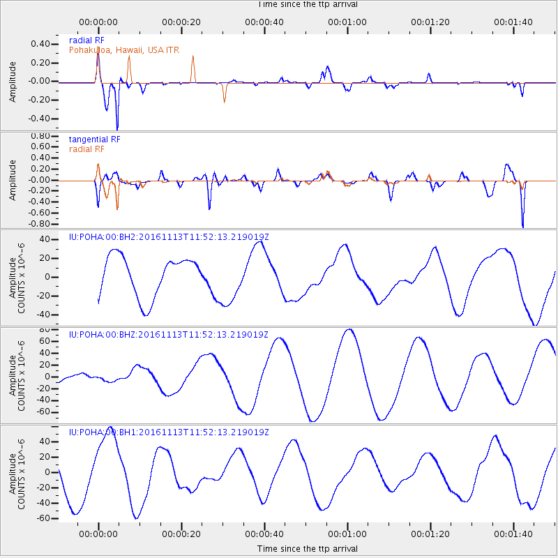
POHA Pohakuloa, Hawaii, USA - Earthquake Result Viewer
*The percent match for this event was below the threshold and hence no stack was calculated.
| Earthquake location: |
Cook Strait, New Zealand |
| Earthquake latitude/longitude: |
-41.8/174.1 |
| Earthquake time(UTC): |
2016/11/13 (318) 11:41:49 GMT |
| Earthquake Depth: |
10 km |
| Earthquake Magnitude: |
5.7 MB |
| Earthquake Catalog/Contributor: |
NEIC PDE/NEIC COMCAT |
|
| Network: |
IU Global Seismograph Network (GSN - IRIS/USGS) |
| Station: |
POHA Pohakuloa, Hawaii, USA |
| Lat/Lon: |
19.76 N/155.53 W |
| Elevation: |
1990 m |
|
| Distance: |
67.4 deg |
| Az: |
31.042 deg |
| Baz: |
204.17 deg |
| Ray Param: |
$rayparam |
*The percent match for this event was below the threshold and hence was not used in the summary stack. |
|
| Radial Match: |
79.39145 % |
| Radial Bump: |
262 |
| Transverse Match: |
61.46065 % |
| Transverse Bump: |
400 |
| SOD ConfigId: |
1858631 |
| Insert Time: |
2016-11-28 15:58:04.653 +0000 |
| GWidth: |
2.5 |
| Max Bumps: |
400 |
| Tol: |
0.001 |
|
Signal To Noise
| Channel | StoN | STA | LTA |
| IU:POHA:00:BHZ:20161113T11:52:13.219019Z | 0.45112517 | 4.4150415E-6 | 9.786733E-6 |
| IU:POHA:00:BH1:20161113T11:52:13.219019Z | 2.079065 | 4.799531E-5 | 2.3085042E-5 |
| IU:POHA:00:BH2:20161113T11:52:13.219019Z | 1.2699383 | 2.6901682E-5 | 2.1183456E-5 |
| Arrivals |
| Ps | |
| PpPs | |
| PsPs/PpSs | |


