You are here: Home > Network List > TA - USArray Transportable Network (new EarthScope stations) Stations List
> Station E18K Tukpahlearik Creek, AK, USA > Earthquake Result Viewer
E18K Tukpahlearik Creek, AK, USA - Earthquake Result Viewer
| Earthquake location: |
Northern Sumatra, Indonesia |
| Earthquake latitude/longitude: |
0.4/97.7 |
| Earthquake time(UTC): |
2019/06/03 (154) 05:57:09 GMT |
| Earthquake Depth: |
16 km |
| Earthquake Magnitude: |
5.8 Mww |
| Earthquake Catalog/Contributor: |
NEIC PDE/us |
|
| Network: |
TA USArray Transportable Network (new EarthScope stations) |
| Station: |
E18K Tukpahlearik Creek, AK, USA |
| Lat/Lon: |
67.42 N/160.60 W |
| Elevation: |
297 m |
|
| Distance: |
94.2 deg |
| Az: |
22.282 deg |
| Baz: |
280.923 deg |
| Ray Param: |
0.04110625 |
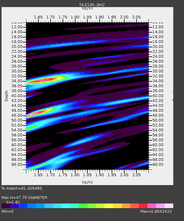
| Estimated Moho Depth: |
47.75 km |
| Estimated Crust Vp/Vs: |
1.61 |
| Assumed Crust Vp: |
6.276 km/s |
| Estimated Crust Vs: |
3.898 km/s |
| Estimated Crust Poisson's Ratio: |
0.19 |
|
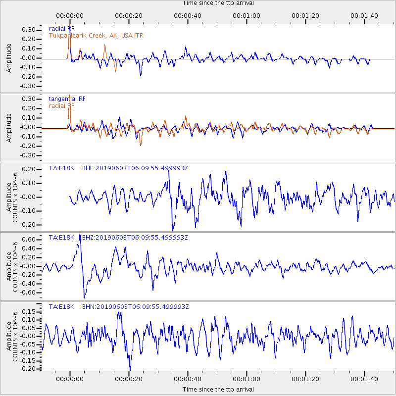
| Radial Match: |
81.405495 % |
| Radial Bump: |
400 |
| Transverse Match: |
73.4707 % |
| Transverse Bump: |
400 |
| SOD ConfigId: |
18369291 |
| Insert Time: |
2019-06-17 05:59:50.378 +0000 |
| GWidth: |
2.5 |
| Max Bumps: |
400 |
| Tol: |
0.001 |
|
Signal To Noise
| Channel | StoN | STA | LTA |
| TA:E18K: :BHZ:20190603T06:09:55.499993Z | 5.9544163 | 3.397146E-7 | 5.7052542E-8 |
| TA:E18K: :BHN:20190603T06:09:55.499993Z | 1.4787648 | 4.259019E-8 | 2.8801194E-8 |
| TA:E18K: :BHE:20190603T06:09:55.499993Z | 1.8955439 | 8.011802E-8 | 4.2266507E-8 |
| Arrivals |
| Ps | 4.7 SECOND |
| PpPs | 19 SECOND |
| PsPs/PpSs | 24 SECOND |


