You are here: Home > Network List > TA - USArray Transportable Network (new EarthScope stations) Stations List
> Station E20K Nigu River, AK, USA > Earthquake Result Viewer
E20K Nigu River, AK, USA - Earthquake Result Viewer
| Earthquake location: |
Northern Sumatra, Indonesia |
| Earthquake latitude/longitude: |
0.4/97.7 |
| Earthquake time(UTC): |
2019/06/03 (154) 05:57:09 GMT |
| Earthquake Depth: |
16 km |
| Earthquake Magnitude: |
5.8 Mww |
| Earthquake Catalog/Contributor: |
NEIC PDE/us |
|
| Network: |
TA USArray Transportable Network (new EarthScope stations) |
| Station: |
E20K Nigu River, AK, USA |
| Lat/Lon: |
68.26 N/156.19 W |
| Elevation: |
866 m |
|
| Distance: |
95.6 deg |
| Az: |
21.083 deg |
| Baz: |
285.11 deg |
| Ray Param: |
0.040736105 |
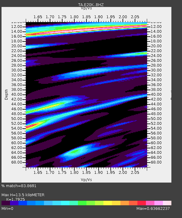
| Estimated Moho Depth: |
13.5 km |
| Estimated Crust Vp/Vs: |
1.79 |
| Assumed Crust Vp: |
6.221 km/s |
| Estimated Crust Vs: |
3.471 km/s |
| Estimated Crust Poisson's Ratio: |
0.27 |
|
| Radial Match: |
83.8691 % |
| Radial Bump: |
400 |
| Transverse Match: |
63.895325 % |
| Transverse Bump: |
400 |
| SOD ConfigId: |
18369291 |
| Insert Time: |
2019-06-17 05:59:51.109 +0000 |
| GWidth: |
2.5 |
| Max Bumps: |
400 |
| Tol: |
0.001 |
|

Signal To Noise
| Channel | StoN | STA | LTA |
| TA:E20K: :BHZ:20190603T06:10:02.049981Z | 5.519449 | 3.8347832E-7 | 6.947764E-8 |
| TA:E20K: :BHN:20190603T06:10:02.049981Z | 1.125279 | 5.291592E-8 | 4.702471E-8 |
| TA:E20K: :BHE:20190603T06:10:02.049981Z | 2.436946 | 1.0627221E-7 | 4.3608768E-8 |
| Arrivals |
| Ps | 1.8 SECOND |
| PpPs | 5.9 SECOND |
| PsPs/PpSs | 7.7 SECOND |


