You are here: Home > Network List > TA - USArray Transportable Network (new EarthScope stations) Stations List
> Station F15K North Star Ditch, AK, USA > Earthquake Result Viewer
F15K North Star Ditch, AK, USA - Earthquake Result Viewer
| Earthquake location: |
Northern Sumatra, Indonesia |
| Earthquake latitude/longitude: |
0.4/97.7 |
| Earthquake time(UTC): |
2019/06/03 (154) 05:57:09 GMT |
| Earthquake Depth: |
16 km |
| Earthquake Magnitude: |
5.8 Mww |
| Earthquake Catalog/Contributor: |
NEIC PDE/us |
|
| Network: |
TA USArray Transportable Network (new EarthScope stations) |
| Station: |
F15K North Star Ditch, AK, USA |
| Lat/Lon: |
65.71 N/164.65 W |
| Elevation: |
388 m |
|
| Distance: |
92.8 deg |
| Az: |
24.238 deg |
| Baz: |
277.096 deg |
| Ray Param: |
0.041378696 |
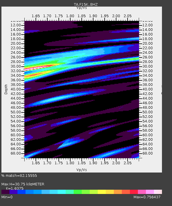
| Estimated Moho Depth: |
30.75 km |
| Estimated Crust Vp/Vs: |
1.64 |
| Assumed Crust Vp: |
6.276 km/s |
| Estimated Crust Vs: |
3.833 km/s |
| Estimated Crust Poisson's Ratio: |
0.20 |
|
| Radial Match: |
82.15555 % |
| Radial Bump: |
400 |
| Transverse Match: |
63.154655 % |
| Transverse Bump: |
400 |
| SOD ConfigId: |
18369291 |
| Insert Time: |
2019-06-17 05:59:53.834 +0000 |
| GWidth: |
2.5 |
| Max Bumps: |
400 |
| Tol: |
0.001 |
|

Signal To Noise
| Channel | StoN | STA | LTA |
| TA:F15K: :BHZ:20190603T06:09:49.424981Z | 7.6420026 | 3.645338E-7 | 4.7701345E-8 |
| TA:F15K: :BHN:20190603T06:09:49.424981Z | 1.4969198 | 7.2234265E-8 | 4.8255266E-8 |
| TA:F15K: :BHE:20190603T06:09:49.424981Z | 3.1388135 | 1.07664576E-7 | 3.4301042E-8 |
| Arrivals |
| Ps | 3.2 SECOND |
| PpPs | 13 SECOND |
| PsPs/PpSs | 16 SECOND |


