You are here: Home > Network List > TA - USArray Transportable Network (new EarthScope stations) Stations List
> Station X24A Lazy VL Ranch, Encino, NM, USA > Earthquake Result Viewer
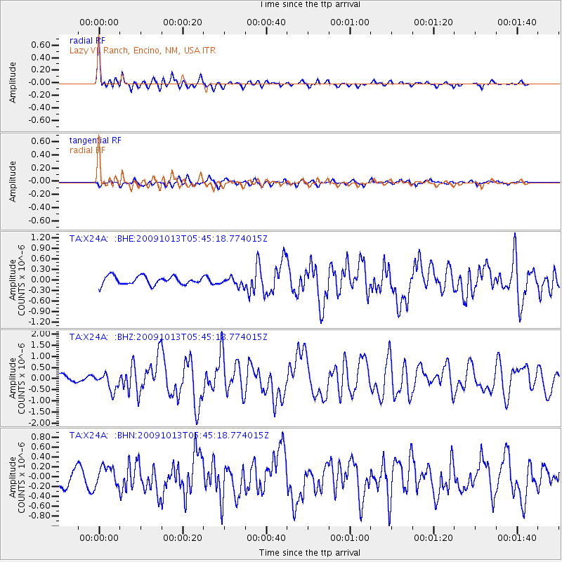
X24A Lazy VL Ranch, Encino, NM, USA - Earthquake Result Viewer

| Earthquake location: |
Fox Islands, Aleutian Islands |
| Earthquake latitude/longitude: |
52.8/-167.0 |
| Earthquake time(UTC): |
2009/10/13 (286) 05:37:23 GMT |
| Earthquake Depth: |
24 km |
| Earthquake Magnitude: |
6.0 MB, 6.1 MS, 6.5 MW, 6.5 MW |
| Earthquake Catalog/Contributor: |
WHDF/NEIC |
|
| Network: |
TA USArray Transportable Network (new EarthScope stations) |
| Station: |
X24A Lazy VL Ranch, Encino, NM, USA |
| Lat/Lon: |
34.56 N/105.43 W |
| Elevation: |
1917 m |
|
| Distance: |
46.6 deg |
| Az: |
87.539 deg |
| Baz: |
312.623 deg |
| Ray Param: |
0.07051874 |
| Estimated Moho Depth: |
43.0 km |
| Estimated Crust Vp/Vs: |
1.78 |
| Assumed Crust Vp: |
6.419 km/s |
| Estimated Crust Vs: |
3.611 km/s |
| Estimated Crust Poisson's Ratio: |
0.27 |
|
| Radial Match: |
89.24117 % |
| Radial Bump: |
397 |
| Transverse Match: |
59.558594 % |
| Transverse Bump: |
400 |
| SOD ConfigId: |
2622 |
| Insert Time: |
2010-03-06 23:17:58.351 +0000 |
| GWidth: |
2.5 |
| Max Bumps: |
400 |
| Tol: |
0.001 |
|
Signal To Noise
| Channel | StoN | STA | LTA |
| TA:X24A: :BHZ:20091013T05:45:18.774015Z | 2.3660939 | 3.942811E-7 | 1.6663797E-7 |
| TA:X24A: :BHN:20091013T05:45:18.774015Z | 0.8349585 | 1.975631E-7 | 2.3661427E-7 |
| TA:X24A: :BHE:20091013T05:45:18.774015Z | 1.0874848 | 1.281523E-7 | 1.1784284E-7 |
| Arrivals |
| Ps | 5.5 SECOND |
| PpPs | 17 SECOND |
| PsPs/PpSs | 23 SECOND |


