You are here: Home > Network List > TA - USArray Transportable Network (new EarthScope stations) Stations List
> Station X24A Lazy VL Ranch, Encino, NM, USA > Earthquake Result Viewer
X24A Lazy VL Ranch, Encino, NM, USA - Earthquake Result Viewer

| Earthquake location: |
Fox Islands, Aleutian Islands |
| Earthquake latitude/longitude: |
52.6/-167.1 |
| Earthquake time(UTC): |
2009/10/13 (286) 20:21:53 GMT |
| Earthquake Depth: |
14 km |
| Earthquake Magnitude: |
5.9 MB, 6.4 MS, 6.4 MW, 6.4 MW |
| Earthquake Catalog/Contributor: |
WHDF/NEIC |
|
| Network: |
TA USArray Transportable Network (new EarthScope stations) |
| Station: |
X24A Lazy VL Ranch, Encino, NM, USA |
| Lat/Lon: |
34.56 N/105.43 W |
| Elevation: |
1917 m |
|
| Distance: |
46.7 deg |
| Az: |
87.304 deg |
| Baz: |
312.421 deg |
| Ray Param: |
0.070495605 |
| Estimated Moho Depth: |
20.0 km |
| Estimated Crust Vp/Vs: |
1.95 |
| Assumed Crust Vp: |
6.419 km/s |
| Estimated Crust Vs: |
3.292 km/s |
| Estimated Crust Poisson's Ratio: |
0.32 |
|
| Radial Match: |
83.5493 % |
| Radial Bump: |
400 |
| Transverse Match: |
51.794567 % |
| Transverse Bump: |
400 |
| SOD ConfigId: |
2622 |
| Insert Time: |
2010-03-06 23:17:59.799 +0000 |
| GWidth: |
2.5 |
| Max Bumps: |
400 |
| Tol: |
0.001 |
|
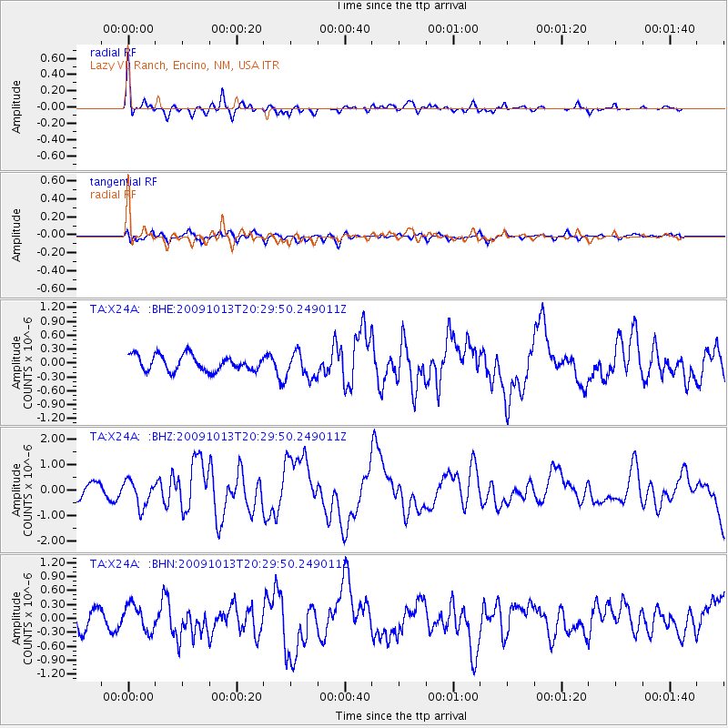
Signal To Noise
| Channel | StoN | STA | LTA |
| TA:X24A: :BHZ:20091013T20:29:50.249011Z | 1.8298501 | 5.231431E-7 | 2.8589398E-7 |
| TA:X24A: :BHN:20091013T20:29:50.249011Z | 1.245695 | 2.856853E-7 | 2.2933807E-7 |
| TA:X24A: :BHE:20091013T20:29:50.249011Z | 1.6742959 | 2.780337E-7 | 1.6606008E-7 |
| Arrivals |
| Ps | 3.1 SECOND |
| PpPs | 8.7 SECOND |
| PsPs/PpSs | 12 SECOND |


