You are here: Home > Network List > TA - USArray Transportable Network (new EarthScope stations) Stations List
> Station X24A Lazy VL Ranch, Encino, NM, USA > Earthquake Result Viewer
X24A Lazy VL Ranch, Encino, NM, USA - Earthquake Result Viewer
| Earthquake location: |
Sea Of Okhotsk |
| Earthquake latitude/longitude: |
54.2/154.3 |
| Earthquake time(UTC): |
2008/11/24 (329) 09:02:58 GMT |
| Earthquake Depth: |
492 km |
| Earthquake Magnitude: |
6.5 MB, 7.3 MW, 7.3 MW |
| Earthquake Catalog/Contributor: |
WHDF/NEIC |
|
| Network: |
TA USArray Transportable Network (new EarthScope stations) |
| Station: |
X24A Lazy VL Ranch, Encino, NM, USA |
| Lat/Lon: |
34.56 N/105.43 W |
| Elevation: |
1917 m |
|
| Distance: |
68.2 deg |
| Az: |
60.979 deg |
| Baz: |
321.5 deg |
| Ray Param: |
0.054768246 |
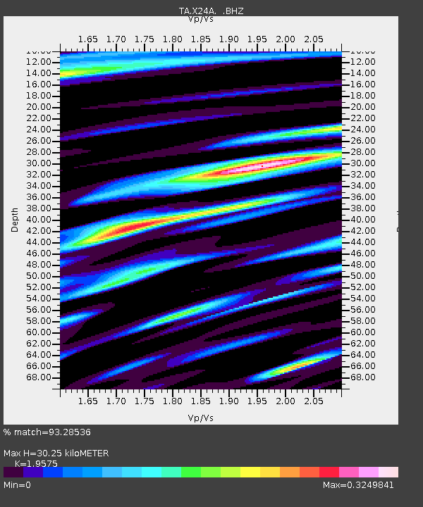
| Estimated Moho Depth: |
30.25 km |
| Estimated Crust Vp/Vs: |
1.96 |
| Assumed Crust Vp: |
6.419 km/s |
| Estimated Crust Vs: |
3.279 km/s |
| Estimated Crust Poisson's Ratio: |
0.32 |
|
| Radial Match: |
93.28536 % |
| Radial Bump: |
343 |
| Transverse Match: |
68.5185 % |
| Transverse Bump: |
400 |
| SOD ConfigId: |
2658 |
| Insert Time: |
2010-03-06 23:18:03.494 +0000 |
| GWidth: |
2.5 |
| Max Bumps: |
400 |
| Tol: |
0.001 |
|
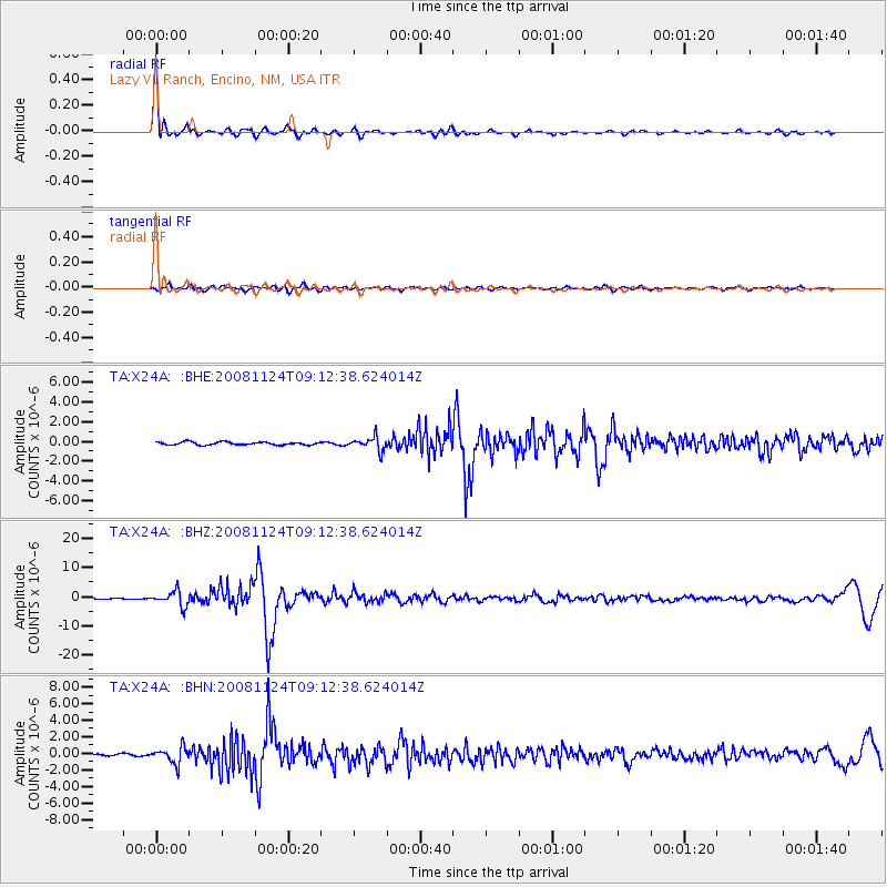
Signal To Noise
| Channel | StoN | STA | LTA |
| TA:X24A: :BHZ:20081124T09:12:38.624014Z | 12.441643 | 2.5419413E-6 | 2.0430912E-7 |
| TA:X24A: :BHN:20081124T09:12:38.624014Z | 4.913322 | 9.708342E-7 | 1.9759223E-7 |
| TA:X24A: :BHE:20081124T09:12:38.624014Z | 4.555851 | 6.679916E-7 | 1.4662281E-7 |
| Arrivals |
| Ps | 4.7 SECOND |
| PpPs | 13 SECOND |
| PsPs/PpSs | 18 SECOND |


