You are here: Home > Network List > TA - USArray Transportable Network (new EarthScope stations) Stations List
> Station M16K Timber Creek, AK, USA > Earthquake Result Viewer
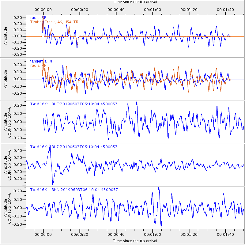
M16K Timber Creek, AK, USA - Earthquake Result Viewer
*The percent match for this event was below the threshold and hence no stack was calculated.
| Earthquake location: |
Northern Sumatra, Indonesia |
| Earthquake latitude/longitude: |
0.4/97.7 |
| Earthquake time(UTC): |
2019/06/03 (154) 05:57:09 GMT |
| Earthquake Depth: |
16 km |
| Earthquake Magnitude: |
5.8 Mww |
| Earthquake Catalog/Contributor: |
NEIC PDE/us |
|
| Network: |
TA USArray Transportable Network (new EarthScope stations) |
| Station: |
M16K Timber Creek, AK, USA |
| Lat/Lon: |
61.02 N/158.96 W |
| Elevation: |
394 m |
|
| Distance: |
96.1 deg |
| Az: |
28.463 deg |
| Baz: |
281.849 deg |
| Ray Param: |
$rayparam |
*The percent match for this event was below the threshold and hence was not used in the summary stack. |
|
| Radial Match: |
63.088764 % |
| Radial Bump: |
400 |
| Transverse Match: |
73.65111 % |
| Transverse Bump: |
400 |
| SOD ConfigId: |
18369291 |
| Insert Time: |
2019-06-17 06:00:18.457 +0000 |
| GWidth: |
2.5 |
| Max Bumps: |
400 |
| Tol: |
0.001 |
|
Signal To Noise
| Channel | StoN | STA | LTA |
| TA:M16K: :BHZ:20190603T06:10:04.450005Z | 4.385098 | 2.40457E-7 | 5.483504E-8 |
| TA:M16K: :BHN:20190603T06:10:04.450005Z | 1.1495552 | 5.0112618E-8 | 4.359305E-8 |
| TA:M16K: :BHE:20190603T06:10:04.450005Z | 1.5472169 | 1.0036701E-7 | 6.486938E-8 |
| Arrivals |
| Ps | |
| PpPs | |
| PsPs/PpSs | |


