You are here: Home > Network List > GM - US Geological Survey Networks Stations List
> Station IWM01 Jericho 2M Well Monitoring Station > Earthquake Result Viewer
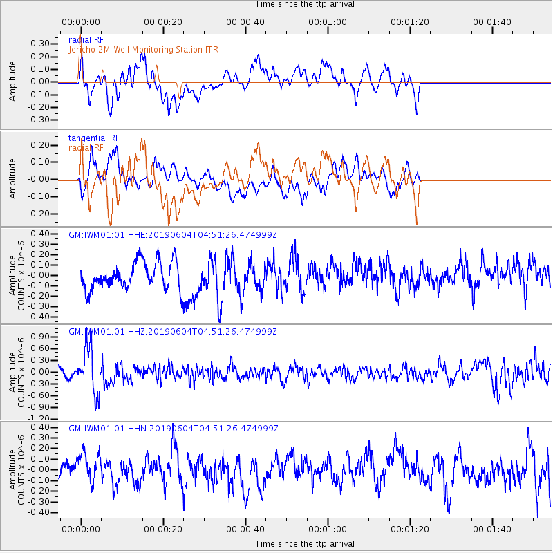
IWM01 Jericho 2M Well Monitoring Station - Earthquake Result Viewer
*The percent match for this event was below the threshold and hence no stack was calculated.
| Earthquake location: |
Southeast Of Honshu, Japan |
| Earthquake latitude/longitude: |
29.1/139.3 |
| Earthquake time(UTC): |
2019/06/04 (155) 04:39:17 GMT |
| Earthquake Depth: |
430 km |
| Earthquake Magnitude: |
6.3 Mww |
| Earthquake Catalog/Contributor: |
NEIC PDE/us |
|
| Network: |
GM US Geological Survey Networks |
| Station: |
IWM01 Jericho 2M Well Monitoring Station |
| Lat/Lon: |
36.73 N/96.53 W |
| Elevation: |
328 m |
|
| Distance: |
96.2 deg |
| Az: |
41.955 deg |
| Baz: |
313.238 deg |
| Ray Param: |
$rayparam |
*The percent match for this event was below the threshold and hence was not used in the summary stack. |
|
| Radial Match: |
48.358562 % |
| Radial Bump: |
400 |
| Transverse Match: |
48.084415 % |
| Transverse Bump: |
400 |
| SOD ConfigId: |
18369291 |
| Insert Time: |
2019-06-18 04:44:04.170 +0000 |
| GWidth: |
2.5 |
| Max Bumps: |
400 |
| Tol: |
0.001 |
|
Signal To Noise
| Channel | StoN | STA | LTA |
| GM:IWM01:01:HHZ:20190604T04:51:26.474999Z | 7.678235 | 6.020604E-7 | 7.8411304E-8 |
| GM:IWM01:01:HHN:20190604T04:51:26.474999Z | 0.8173376 | 1.199584E-7 | 1.4676726E-7 |
| GM:IWM01:01:HHE:20190604T04:51:26.474999Z | 1.5121335 | 1.9646139E-7 | 1.2992331E-7 |
| Arrivals |
| Ps | |
| PpPs | |
| PsPs/PpSs | |


