You are here: Home > Network List > TA - USArray Transportable Network (new EarthScope stations) Stations List
> Station V23A Ortiz Mt. (NFS), Santa Fe National Forest, NM, USA > Earthquake Result Viewer
V23A Ortiz Mt. (NFS), Santa Fe National Forest, NM, USA - Earthquake Result Viewer
| Earthquake location: |
Off East Coast Of Honshu, Japan |
| Earthquake latitude/longitude: |
37.6/142.2 |
| Earthquake time(UTC): |
2008/07/19 (201) 02:39:28 GMT |
| Earthquake Depth: |
22 km |
| Earthquake Magnitude: |
6.2 MB, 7.0 MS, 7.0 MW, 6.9 MW |
| Earthquake Catalog/Contributor: |
WHDF/NEIC |
|
| Network: |
TA USArray Transportable Network (new EarthScope stations) |
| Station: |
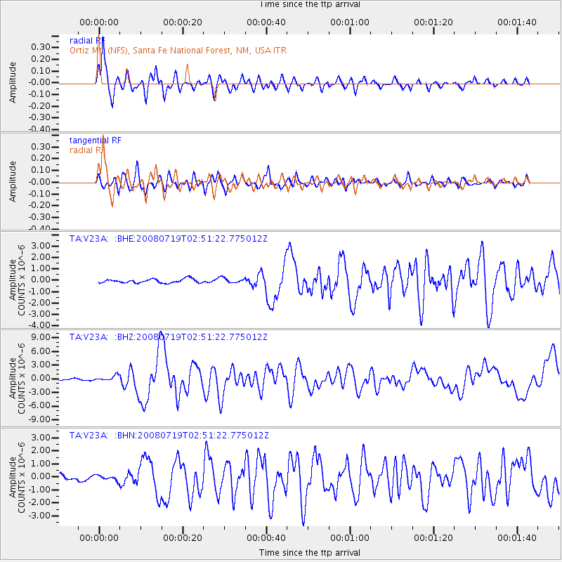
V23A Ortiz Mt. (NFS), Santa Fe National Forest, NM, USA |
| Lat/Lon: |
35.75 N/106.18 W |
| Elevation: |
1991 m |
|
| Distance: |
83.4 deg |
| Az: |
49.586 deg |
| Baz: |
311.937 deg |
| Ray Param: |
0.046193764 |
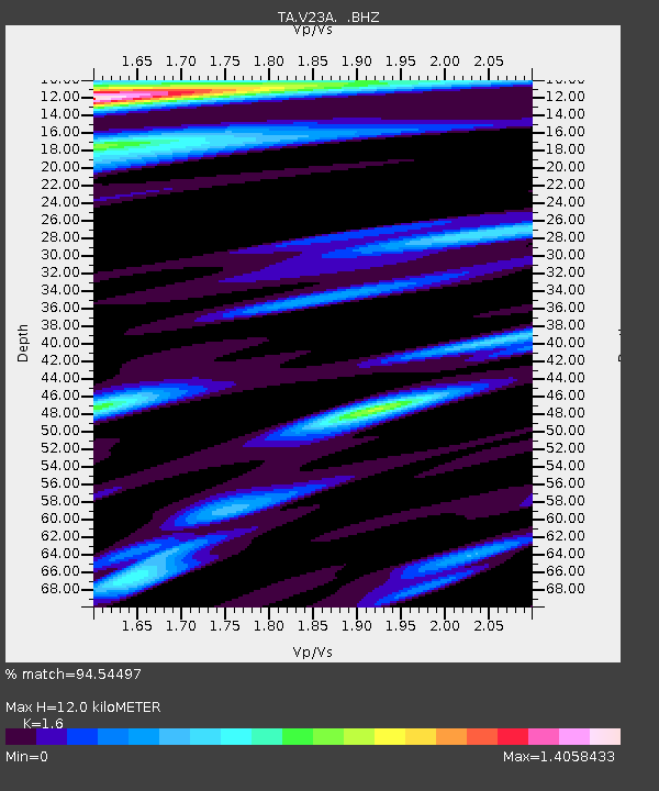
| Estimated Moho Depth: |
12.0 km |
| Estimated Crust Vp/Vs: |
1.60 |
| Assumed Crust Vp: |
6.502 km/s |
| Estimated Crust Vs: |
4.063 km/s |
| Estimated Crust Poisson's Ratio: |
0.18 |
|
| Radial Match: |
94.54497 % |
| Radial Bump: |
400 |
| Transverse Match: |
84.35143 % |
| Transverse Bump: |
400 |
| SOD ConfigId: |
2504 |
| Insert Time: |
2010-03-06 23:20:13.300 +0000 |
| GWidth: |
2.5 |
| Max Bumps: |
400 |
| Tol: |
0.001 |
|
Signal To Noise
| Channel | StoN | STA | LTA |
| TA:V23A: :BHZ:20080719T02:51:22.775012Z | 4.0974116 | 6.243513E-7 | 1.5237701E-7 |
| TA:V23A: :BHN:20080719T02:51:22.775012Z | 0.95901686 | 1.9496747E-7 | 2.0329931E-7 |
| TA:V23A: :BHE:20080719T02:51:22.775012Z | 1.2847198 | 2.1827415E-7 | 1.6990019E-7 |
| Arrivals |
| Ps | 1.1 SECOND |
| PpPs | 4.7 SECOND |
| PsPs/PpSs | 5.8 SECOND |


