You are here: Home > Network List > GS - US Geological Survey Networks Stations List
> Station KAN13 Rinehart Farm > Earthquake Result Viewer
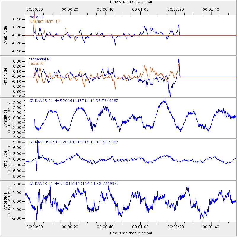
KAN13 Rinehart Farm - Earthquake Result Viewer
*The percent match for this event was below the threshold and hence no stack was calculated.
| Earthquake location: |
La Rioja Province, Argentina |
| Earthquake latitude/longitude: |
-28.9/-67.5 |
| Earthquake time(UTC): |
2016/11/13 (318) 14:01:01 GMT |
| Earthquake Depth: |
110 km |
| Earthquake Magnitude: |
6.2 MB, 5.7 MWR |
| Earthquake Catalog/Contributor: |
NEIC PDE/NEIC COMCAT |
|
| Network: |
GS US Geological Survey Networks |
| Station: |
KAN13 Rinehart Farm |
| Lat/Lon: |
37.01 N/97.48 W |
| Elevation: |
340 m |
|
| Distance: |
71.3 deg |
| Az: |
335.004 deg |
| Baz: |
152.419 deg |
| Ray Param: |
$rayparam |
*The percent match for this event was below the threshold and hence was not used in the summary stack. |
|
| Radial Match: |
81.39872 % |
| Radial Bump: |
400 |
| Transverse Match: |
63.598957 % |
| Transverse Bump: |
342 |
| SOD ConfigId: |
1858631 |
| Insert Time: |
2016-11-28 16:02:10.486 +0000 |
| GWidth: |
2.5 |
| Max Bumps: |
400 |
| Tol: |
0.001 |
|
Signal To Noise
| Channel | StoN | STA | LTA |
| GS:KAN13:01:HHZ:20161113T14:11:38.724998Z | 2.0393744 | 2.7946448E-6 | 1.3703442E-6 |
| GS:KAN13:01:HHN:20161113T14:11:38.724998Z | 0.7693029 | 1.1000778E-6 | 1.429967E-6 |
| GS:KAN13:01:HHE:20161113T14:11:38.724998Z | 0.6578758 | 9.598155E-7 | 1.4589616E-6 |
| Arrivals |
| Ps | |
| PpPs | |
| PsPs/PpSs | |


