You are here: Home > Network List > TA - USArray Transportable Network (new EarthScope stations) Stations List
> Station V23A Ortiz Mt. (NFS), Santa Fe National Forest, NM, USA > Earthquake Result Viewer
V23A Ortiz Mt. (NFS), Santa Fe National Forest, NM, USA - Earthquake Result Viewer
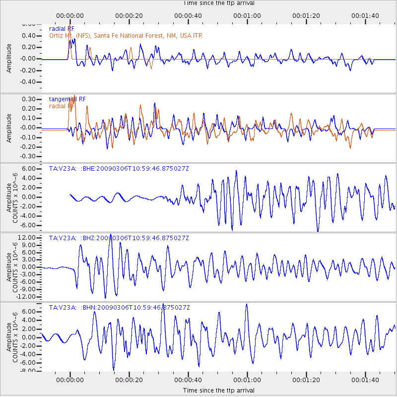
| Earthquake location: |
North Of Svalbard |
| Earthquake latitude/longitude: |
80.3/-1.9 |
| Earthquake time(UTC): |
2009/03/06 (065) 10:50:29 GMT |
| Earthquake Depth: |
9.0 km |
| Earthquake Magnitude: |
6.6 MB, 6.5 MS, 6.5 MW, 6.4 MW |
| Earthquake Catalog/Contributor: |
WHDF/NEIC |
|
| Network: |
TA USArray Transportable Network (new EarthScope stations) |
| Station: |
V23A Ortiz Mt. (NFS), Santa Fe National Forest, NM, USA |
| Lat/Lon: |
35.75 N/106.18 W |
| Elevation: |
1991 m |
|
| Distance: |
57.4 deg |
| Az: |
290.637 deg |
| Baz: |
11.223 deg |
| Ray Param: |
0.06353365 |
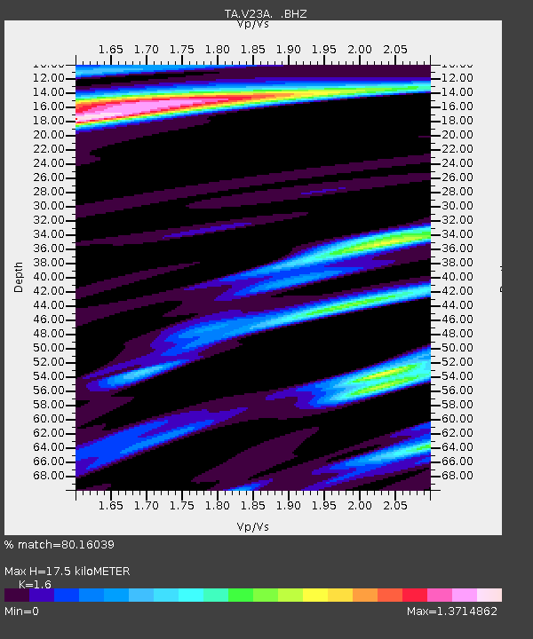
| Estimated Moho Depth: |
17.5 km |
| Estimated Crust Vp/Vs: |
1.60 |
| Assumed Crust Vp: |
6.502 km/s |
| Estimated Crust Vs: |
4.063 km/s |
| Estimated Crust Poisson's Ratio: |
0.18 |
|
| Radial Match: |
80.16039 % |
| Radial Bump: |
400 |
| Transverse Match: |
82.54742 % |
| Transverse Bump: |
400 |
| SOD ConfigId: |
2658 |
| Insert Time: |
2010-03-06 23:20:34.354 +0000 |
| GWidth: |
2.5 |
| Max Bumps: |
400 |
| Tol: |
0.001 |
|
Signal To Noise
| Channel | StoN | STA | LTA |
| TA:V23A: :BHZ:20090306T10:59:46.875027Z | 21.065916 | 4.5578663E-6 | 2.1636212E-7 |
| TA:V23A: :BHN:20090306T10:59:46.875027Z | 3.107798 | 1.7353983E-6 | 5.584012E-7 |
| TA:V23A: :BHE:20090306T10:59:46.875027Z | 0.85287297 | 4.1967712E-7 | 4.920746E-7 |
| Arrivals |
| Ps | 1.7 SECOND |
| PpPs | 6.6 SECOND |
| PsPs/PpSs | 8.3 SECOND |


