You are here: Home > Network List > IU - Global Seismograph Network (GSN - IRIS/USGS) Stations List
> Station RSSD Black Hills, South Dakota, USA > Earthquake Result Viewer
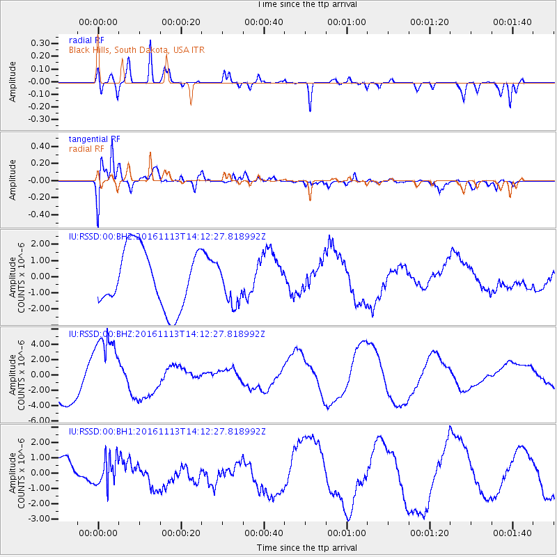
RSSD Black Hills, South Dakota, USA - Earthquake Result Viewer
*The percent match for this event was below the threshold and hence no stack was calculated.
| Earthquake location: |
La Rioja Province, Argentina |
| Earthquake latitude/longitude: |
-28.9/-67.5 |
| Earthquake time(UTC): |
2016/11/13 (318) 14:01:01 GMT |
| Earthquake Depth: |
110 km |
| Earthquake Magnitude: |
6.2 MB, 5.7 MWR |
| Earthquake Catalog/Contributor: |
NEIC PDE/NEIC COMCAT |
|
| Network: |
IU Global Seismograph Network (GSN - IRIS/USGS) |
| Station: |
RSSD Black Hills, South Dakota, USA |
| Lat/Lon: |
44.12 N/104.04 W |
| Elevation: |
2090 m |
|
| Distance: |
80.0 deg |
| Az: |
334.168 deg |
| Baz: |
147.952 deg |
| Ray Param: |
$rayparam |
*The percent match for this event was below the threshold and hence was not used in the summary stack. |
|
| Radial Match: |
65.994484 % |
| Radial Bump: |
400 |
| Transverse Match: |
55.826584 % |
| Transverse Bump: |
400 |
| SOD ConfigId: |
1858631 |
| Insert Time: |
2016-11-28 16:02:48.629 +0000 |
| GWidth: |
2.5 |
| Max Bumps: |
400 |
| Tol: |
0.001 |
|
Signal To Noise
| Channel | StoN | STA | LTA |
| IU:RSSD:00:BHZ:20161113T14:12:27.818992Z | 2.1378002 | 4.719936E-6 | 2.2078473E-6 |
| IU:RSSD:00:BH1:20161113T14:12:27.818992Z | 0.87575483 | 9.142E-7 | 1.0438995E-6 |
| IU:RSSD:00:BH2:20161113T14:12:27.818992Z | 0.67904997 | 1.2163302E-6 | 1.7912234E-6 |
| Arrivals |
| Ps | |
| PpPs | |
| PsPs/PpSs | |


