You are here: Home > Network List > IU - Global Seismograph Network (GSN - IRIS/USGS) Stations List
> Station TEIG Tepich, Yucatan, Mexico > Earthquake Result Viewer
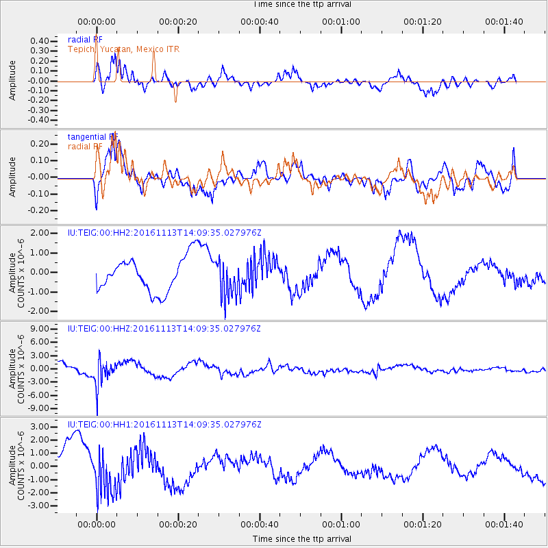
TEIG Tepich, Yucatan, Mexico - Earthquake Result Viewer
*The percent match for this event was below the threshold and hence no stack was calculated.
| Earthquake location: |
La Rioja Province, Argentina |
| Earthquake latitude/longitude: |
-28.9/-67.5 |
| Earthquake time(UTC): |
2016/11/13 (318) 14:01:01 GMT |
| Earthquake Depth: |
110 km |
| Earthquake Magnitude: |
6.2 MB, 5.7 MWR |
| Earthquake Catalog/Contributor: |
NEIC PDE/NEIC COMCAT |
|
| Network: |
IU Global Seismograph Network (GSN - IRIS/USGS) |
| Station: |
TEIG Tepich, Yucatan, Mexico |
| Lat/Lon: |
20.23 N/88.28 W |
| Elevation: |
40 m |
|
| Distance: |
52.8 deg |
| Az: |
335.235 deg |
| Baz: |
156.968 deg |
| Ray Param: |
$rayparam |
*The percent match for this event was below the threshold and hence was not used in the summary stack. |
|
| Radial Match: |
73.583466 % |
| Radial Bump: |
400 |
| Transverse Match: |
66.89799 % |
| Transverse Bump: |
400 |
| SOD ConfigId: |
1858631 |
| Insert Time: |
2016-11-28 16:02:55.319 +0000 |
| GWidth: |
2.5 |
| Max Bumps: |
400 |
| Tol: |
0.001 |
|
Signal To Noise
| Channel | StoN | STA | LTA |
| IU:TEIG:00:HHZ:20161113T14:09:35.027976Z | 2.720672 | 2.889441E-6 | 1.0620322E-6 |
| IU:TEIG:00:HH1:20161113T14:09:35.027976Z | 1.40722 | 1.6556571E-6 | 1.1765446E-6 |
| IU:TEIG:00:HH2:20161113T14:09:35.027976Z | 1.0655392 | 9.413694E-7 | 8.834677E-7 |
| Arrivals |
| Ps | |
| PpPs | |
| PsPs/PpSs | |


